
Why use digital twins in construction
Everything around us is going digital. Advanced technologies like artificial intelligence and Internet of Things (IoT) are increasingly becoming important parts of each industry, making processes faster and more efficient in terms of cost, time and traceability. Going digital is enabling every industry to achieve more with less; at least this is the optimization sought by the latest advances in computing power and smart algorithms, along with technological developments in sensors, miniaturization, robotics, and drones, are helping even the construction industry to realize how they can combine the digital and physical worlds to build cheaper, greener and safer buildings in less time.
An example of this is how drones allow the capture of a large number of photographs in a short period of time, which facilitates the planning task. But not only that, since depending on the sensor that the drone has, data could be obtained at the same time with which physical characteristics can be modeled that give greater added value to simple fluid photogrammetry. This concept that is really changing the face of the AEC industry is that of “Digital Twins” and recent examples of Hololens2 augmented reality evidence that we will have much of this beyond the entertainment industry.
According to a recent Gartner report, the trend of "Digital Twin" is approaching the "Peak of Inflated Expectations". What else? Within 5 to 10 years, the trend is expected to reach the "Plateau of Productivity".

What is a digital twin?
A digital twin refers to a virtual model of a process, product or service. A digital twin is a link between a real-world object and its digital representation that is continuously using data from the sensors. All data comes from the sensors located on a physical object. The digital representation is later used for visualization, modeling, analysis, simulation and further planning.
Unlike BIM modeling, the digital twin does not necessarily address an object with spatial representation. For example, a transactional process, a file of a person, or a set of relationships between interested parties and administrative units.
Of course, the digital twin of infrastructures is the most attractive, at least in the field of Geo-engineering. By creating a building's digital twin, building owners and operators can prevent the many problems that occur within the building, adopt construction strategies, and consequently have safer buildings. For example, you can create a digital twin of a building and check how it will react to a large earthquake. Depending on the outcome, you can make the necessary changes to the building, before the calamity strikes and things get out of hand. This is how a building's digital twin can save lives.

The digital twins allow a building designer to have all the information related to the building available in real time, associated with a life file that includes the conception, design, construction, maintenance and operation of the asset. It provides instant access to all the information about a construction site. It helps builders to always be sure of even the tiniest things, like the required measures of a beam.
As recently shared by Mark Enzer, CTO, MottMacDonald in the SMART Summit 2019 while speaking about the update frequency of digital twins; “It’s not about real time, but about the right time."
Advantages of using digital twins in construction.

The right use of technology always makes processes more efficient. For instance, digital twins, by enabling simulations to have the potential to bring the damage caused due to both natural and man-made disasters. They can help citizens lead a safer life. For instance, in the case of infrastructures where there is supposed to be a lot of traffic, through the use of pedestrian simulation software, we can predict when and where there will be more congestion. By bringing in requisite changes in the digital model of the infrastructure, it is possible to achieve higher safety, efficiency, & less operational costs in building and maintaining the asset.
The advantages of using digital twins in construction are many. Some of them are detailed below:
Continuous monitoring of construction progress.
Real-time monitoring of a construction site by way of a digital twin verifies that the completed work is consistent with plans and specifications. With digital twins, it is possible to track the changes in an as-built model, daily and hourly, and in case of any deviation, immediate action can be taken. Additionally, the condition of concrete, cracks on columns or any material displacement at the construction site can also be checked in a digital twin easily. Such discoveries lead to additional inspections and problems get detected faster, leading to faster solutions.
Optimal use of resources.
Digital Twins even lead to better allocation of resources and help the companies avoid wasting productive time on unnecessary movement and handling of materials. With the use of this technology, over-allocation can be avoided and also becomes easier to dynamically predict resource requirements onsite.
Even equipment usage can be tracked and unused ones can be released for other works. This saves time and money.
Safety monitoring.
Safety is a huge concern in construction sites. Digital twins, by allowing companies to track people and hazardous places on a construction site, helps prevent usage of unsafe materials and activity in hazardous zones. Based on the real-time input, an early notification system can be developed that can let a construction manager know when a field worker is located in an unsafe region. A notification can also be sent to the worker’s wearable device to prevent a hazard from happening. Such a system ensures higher safety and no to minimal accidents at the site.
The advantages of using digital twin technology in construction are numerous. Old habits are hard, but to achieve greater efficiency in construction, it is necessary to go digital. The use of digital twin technology can bring immense innovation to the development of infrastructure and bring quality and efficiency to new heights. The industry must prepare and adapt to the changing digital environment!
A case in point
We had the opportunity to interview Brazilian colleagues last year, in London. By using a digital twin, Brazil's Governador José Richa Airport (SBLO), the fourth-largest airport in southern Brazil is better able to manage airport data and achieve greater efficiency in its operations.
Feeling the need to better organize the airport data, the airport operator of SBLO, Infraero decided to create a digital twin that would act as a reality mesh and a central repository for all airport data, including infrastructure, buildings, building systems, facilities, and maps and management data.
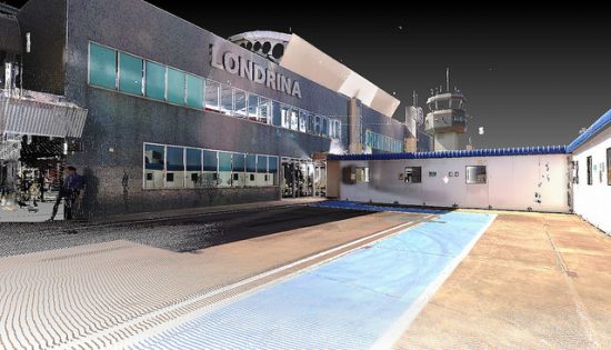 BIM and GIS along with Bentley applications were used to model 20 existing facilities, covering more than 920,000 square meters of airport surface area. They also modeled one takeoff and landing runway, two aircraft yards, and the system of taxiways and access roads. The project team then created a parametric database to support planning and improve project management.
The project team created a digital twin of the airport that includes a reality mesh of the airport and a central repository for all airport data. The central repository helps users to accurately identify the location of systems within the airport’s infrastructure, improving business management with safe and efficient operations. The digital twin will also streamline all future internal airport infrastructure projects, as well as planning and management processes. With the help of the digital twin, Infraero is able to reduce maintenance cost and achieve improved airport operation at SBLO. The project team expects to save over BRL 559,000 per year with its digital twin. The organization also expects to see an increase in its profitability.
Software used
 ProjectWise was used to create the airport integration platform, which served as the project’s connected data environment. MicroStation’s point cloud import capability allowed the team to create the reality mesh of the entire airport facility using point clouds. OpenBuildings Designer (formerly AECOsim Building Designer) helped design and organize airport facility libraries, as well as model the existing passenger terminal, cargo terminal, fire station, and other buildings. The team used OpenRoads to create the geometric project and runway system surfaces map for takeoff and landing runways, taxiways, and service roads.


