
Civil 3D, create an alignment (3 lesson)
In the two previous lessons we saw How to import dots y Customize them. Now we want to make an alignment from the points marked as stations.
Create the polyline
For that, we use the polyline command and we use the snap command to the nodes. We go from the initial station to the final one.
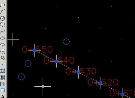
Create alignment
For this we say "alignment / create alignment from polyline"
then we touch the polyline and a panel is raised that for now we pay no more attention than to name the alignment. We will call it "Calle Mel Zelaya"

And there my friends have it.
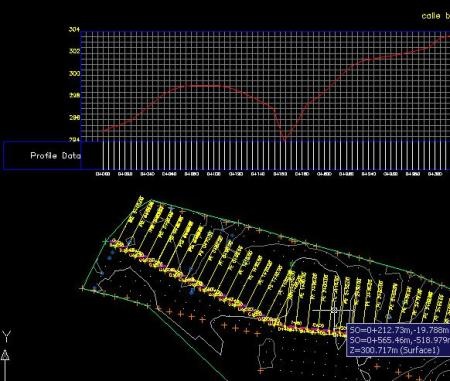
Ah, you want to create a surface?
Right click on surface, new and well you can call "Surface Hugo Chávez"
Now right click on "definition / point groups" and we say that all those points are the ones that make up the surface.

Well, there we continue after I'm confusing composure. Try in the meantime to create profiles from the alignments and on the created surface.


Hi friends can you tell me how to make a longitudinal profile through an alignment already with its parked
I need to do an alignment (abide a polylinea in autocad 2014
Did you find out how?
The alignment comes out in inches, as I do for q me in meters or rather my actual distance
I would like you to help me convert an alignment into a polyline in 3d …… Civil 3d is beating me …… ..
Thank you to anyone who can support me in this problem.
Hi friends, thank you for this very interesting contribution. Go ahead. Congratulations. Take care. If the road stretch is too long, I can cut those sections.
When you create an alignment, for example, create from a polyline, and you see a panel to assign properties, the third box called
“starting station” lets you set the starting point
Hello, how are you? Super ...
It is the first time that I have the pleasure to see this site ..
This is very interesting… ..
I have a question ... how to change the mileage I want it this way
0 + 123.25…. But I appeared this way 1 + 23.25 and I haven't found a way to fix it… tell me… say hello, blessings….
1ra time that I see the site I find very interesting what they do so continue,
I wish I had less trips, and fewer school tasks my boys.
But we'll see.
Greetings friends of geofumadas, their topics are very interesting, they can help me to create cross sections and calculate volumes, then create horizontal and vertical project slides per kilometer and place project quota label, natural terrain, cut quota, Filling and abscissa.
I hope you can help me, thank you very much
Sincerely,
Victor
Hello Alfonso, interesting topic, I wanted to talk about it. I'll take a while, when I return from my trip ... I hope it's not too late.
Hello friends of geofumadas…. It is an excellent contribution from you with this program as good and wide as civil 3d is…. I am a civil engineer and I would like you to please help me with a particular issue such as the calculation of volumes between two surfaces but limited by a rectangle ... that is, in a sector of the land ... and if tables can be presented with the calculation of volumes together with sections where you can see the lines that define the native land and the line where the cut has reached…. Thanks in advance and I look forward to your response soon… ..
Keep it up… .. Greetings