
Almost ready the Manifold manual for municipal use
Some time ago I told you about being bogged down making a manual, as it is almost ready thanks to the brilliant support of a technician who learned to use Manifold by force but is now an expert. With it we build the index and it has been the one that has developed the experimental part of a large part of the document.
Municipal SIG in Manifold System
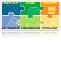 The objective of the manual is to constitute a basic and practical guide for the implementation of a Geographic Information System in a municipality or town hall using Manifold GIS. It is built based on the modular contextual scalability of the GIS projects that I told you about some time ago and each section is made up of a methodology "what is it", "how is it done" and "what product is obtained". Below is the index.
I. INTRODUCTION
II. BACKGROUND
 III. CHAPTER 1: DATA CONSTRUCTION
1.1 IMPORT CAD DATA
What is CAD data
How to import CAD data into Manifold's GIS
What product is obtained
1.2 IMPORT GIS DATA
What are GIS data
How to import GIS data into the Manifold project
What product is obtained
1.3 IMPORT AND LINKE RASTER IMAGES
What are raster images
How raster images are imported
How to link raster images.
What product is obtained.
1.4 SYSTEM OF COORDINATES (PROJECTION AND DATUM) OF THE COMPONENTS
What is a projection
How the projection is assigned to the components of the SIG
What product is obtained
1.5 DRAWING OBJECTS
What kind of objects are drawn in Manifold
How objects are drawn in Manifold
What product is obtained
1.6 CONSTRUCTION OF TABLES
What are the tables in Manifold
How the Tables are created and handled
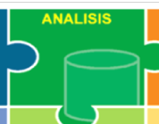 IV. CHAPTER 2: DATA ANALYSIS
2.1 DATA SYMBOLIZATION
What is symbolization of data in Manifold
How data symbolization is done in Manifold
What product is obtained
2.4 DATA TEMATIZATION
What is the thematization of data in Manifold
How data thematization is done in Manifold
What product is obtained
2.3 TOPOLOGICAL ANALYSIS
What is topological analysis
How Topological Analysis is applied in Manifold components
What product is obtained
2.4 SPACE ANALYSIS
What is spatial analysis
How spatial analysis is applied in Manifold Components
What product is obtained
2.5 LINK BETWEEN TABLES
What is linkage of tables
Creating links between tables
What product is obtained
 V. CHAPTER 3: PUBLISHING DATA IN MANIFOLD SIG
3.1 PRINTING IN LAYOUTS
What are layouts
How Layouts are created
What product is obtained
3.2 LEGENDS (LEGENDS)
What are legends
How the legends are added
What product is obtained
3.3 EXPORT COMPONENTS
Why export components
How components are exported
What product is obtained
3.4 SHARED JOB MODEL
To share components
How the components are shared
What product is obtained
 VI. CHAPTER 4: GIS DATA MAINTENANCE
4.1 EDITION OF OBJECTS
What is the edition of objects
How to edit objects
What product is obtained
4.2 EDITION OF TABLES
How to edit tables
What product is obtained
 VII. CHAPTER 5: DATA MANAGEMENT
5.1 ADMINISTRATION AND BACKUP OF DATA
What is a backup
How information can be managed
How a backup is made
What product is obtained
 VIII. CHAPTER 6: DATA EXCHANGE
6.1 PUBLICATION IMS (IMAGE MAP SERVICES)
What are IMS map services?
How IMS data can be served using Manifold
What product is obtained
6.2 WMS CONNECTION (Google Earth and others)
What are wms services?
How can you connect to Google Earth, Virtual Earth and other wms services
What product is obtained
6.3 WFS, WCS EXCHANGE
What are the wfs and wcs services
How to serve data and connect to wfs / wcs data
What product is obtained
6.4 EXTO SIG, CAD, RASTER
What other SIG / CAD / RASTER formats exist
How to export to other formats
What product is obtained
6.5 VIA APCL CONTROLLED MAINTENANCE
What is APCL (Parcelario Local Cadastre Application)
How APCL is implemented
What product is obtained
IX. BIBLIOGRAPHY
Finally Manifold manual it stayed like this.


For those who are waiting for the document, here is already published via scribd
I urgently need to get the Manifold manual, how can I get it in Argentina?
If I'm interested If you send it to me, you will help me a lot.
Thank you.
How do I get this manual? I need to learn how to use this software with extreme urgency
there only if you want it in an "as is" version. Let me know and I'll email it to you
I'm a Manifold 8.0 user and I'm surprised at its power, however, I have little time to learn and use it. I am very interested in getting the manual.
Greetings from Mexico !!!!
We hope to release it in January of 2009
I am trying to turn to use Manifold but I have to admit that it has complicated a bit and I would like to know how I can access the manual they are elaborating thanks in advance
Regards!!!
Very interesting, I also learned to use manifold by force just like your colleague. The municipality of the place where I live does not have a territorial administration system and for some time I have been analyzing the possibility of a geofumada with manifold, because of its low cost and how powerful it is, however, I am always in doubt as to whether I will be able to train people in the use of the tool because it is not easy to learn for someone who is not disabled with a sig, even for someone who is.
Well I hope you find the manual well, I will follow it carefully.
regards
Claudio Romero