Web service of old maps among the most outstanding of Mapping Volume 28-124
In its most recent publication the volume 28 -for the month of March and April 2019- Mapping magazine has set as its central theme everything related to the IX Iberian Conference on Spatial Data Infrastructures.  Within the selection of seven scientific articles, published in this journal of importance for the geoscientific field, at least four topics stand out, of which we make a brief description.
MAPPING is a technical-scientific publication with 28 years of history that aims to disseminate research, projects and work carried out in the field of Geomatics and related disciplines, with special attention to their application in the field of Earth Sciences.
At the discretion of our editor, the themes chosen were the following:
- Old maps web service
- Data service of the Marine Technology Unit (UTM-CSIC),
- Implementation of the INSPIRE model in the Diputación Foral de Álava
- INSPIRE Quality Control in metadata, data and services: how to use abstract and executable test sets.
-
Old Maps web service
It is one of the pieces of investigation, that caught our attention just by looking at the title; written by Alvaro Bachiller, Carolina Soteres, and four other co-authors. The premise says a lot; to know the future we must know what happened in the past, what definitely applies to the geographical space.
This project of publishing old maps - called La Cartoteca - started from year 2008, and is being carried out by the CNIG - National Geographic Information Center, in collaboration with the department of the Territory of the National Geographic Institute and the National Geographic Institute - IGN. The interesting thing is that the aforementioned institutions have managed to collect a large amount of historical spatial information since the sixteenth century through the team that makes up the Map Library.
"Historical maps contribute to identifying morphologies, structures built prior to what is currently known, and allows generating more concrete analyzes, projections of what has been and will continue to be the space, as well as being a national heritage."
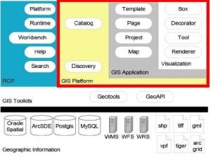
Several of these valuable documents, including population maps, thematic maps, or cadastral topographic plans, can already be consulted by the student, professional or amateur public. This is materialized by the disposition of the CNIG, to offer Web Map Services - in WMS protocols - to serve as a repository for this large amount of data.
In the WMS, you can have access to multiple services such as:
- Kilometer sheets - cadastral topographic plans: with a scale of 1: 2000. This historical document was lifted between 1861 and 1870; by the General Board of Statistics - predecessor of the IGN.
- Planimetry: These are layers that show manuscript plans made between 1870 and 1950, prior to the construction of the national topographic map at the 1: 50.000 scale.
- First Editions of the National Topographic Map - MTN, generated between the dates of 1875 and 1968. This service includes two other types of cartographic documents:
- the MTN minutes made between 1915 to 1960,
- First Edition of the MTN: composed of 4123 sheets, and created from 1975 to 2003.
 Spatial data applies at the national level, however, in the case of cities of great strategic and historical importance such as Madrid, a large amount of related information has been compiled and it is offered in the same web mapping service - WMS. The information on the historical cartography of Madrid is very different from the aforementioned, there are data such as: Mancelli plan of Madrid, topographic plan of the Villa and Madrid court, Nicolás de Chalmadrier plan, geometric plan of Madrid, plan of Madrid and parcel map of Madrid
In this article, they indicate the other services associated with the CNIG download platform, such as the orthophoto query, and the technologies used to make this project possible through the historical Orthophotography service. This service provides six types of layers for users:
- American flights: B series (1956 AND 1957),
- Interministerial flight: works of the Superior Council of Spain between 1976 and 1986,
- Domestic flight: 1 scale: 18.000 between 1981 and 1983,
- OLISTAT flight: promoted by the Ministry of Agriculture, for the olive provinces between 1997 and 1998,
- and PNOA Flights: it covers the whole national surface with a frequency of three years, only data from 2004 to 2016 are included.
 In addition to the aforementioned, on the location, nature and date of creation of the products, it is indicated how the data has been treated, since spatial information that dates back more than 100 years, requires a preparation process , evaluation and storage even more delicate than for more recent spatial data. An example of this treatment is that these maps are a type of secondary data, go through digitalization processes by means of a professional photogrammetric and georeferenced scanner, 400 pp -for smaller scales- and 254 pp -for larger scales- , to then store them in the CNIG servers, which will be decided according to their size if they are sent to the WMS server or saved on an external disk.
It should also be mentioned that the authors detail how the evolution of the project itself has been in recent years, since its opening to the public, showing statistics that indicate: the type of server, number of visits, number of requests, downloads in (Gb) and the platforms that host the data.
-
Data service of the Marine Technology Unit (UTM-CSIC),
In this research, conducted by Juan Valderrama, Susana Tagarro, and two other coauthors, describes the work of the Marine Technology Unit, which aims to provide state entities, information regarding ocean areas such as salinity or surface temperature.
This unit does an interesting job, since it has to collect and analyze data collected every 24 hours, so we assume it translates into a high volume of different nature due to the activity in the oceans. In this research, it is interesting to highlight the restriction of the use of the data collected in the field, which are subsequently treated, analyzed and transferred to the governing body - Ministry of Science, Innovation and Universities.

The article mentions the implications of the consolidation of a Marine Spatial Data Infrastructure for Oceanographic Vessels, each and every one of the phases required to achieve this objective is presented, such as: determination of the professions that will make up the collection team, analysis and custody of data (physicochemical, biologists, geologists, or meteorologists), the construction of metadata, directories, implementation of a catalog of campaigns - which will indicate the type of data necessary for the generation of the final product-, software requirements (in this Geonetwork case)
-
Implementation of the INSPIRE model in the Diputación Foral de Álava
This project created by Jorrín Abellán and Óscar Diego Alonzo, is strictly related to the main theme of the journal for this volume, so they begin by giving reasons for the importance of the construction and implementation of the Spatial Data Infrastructures - IDEs and how INSPIRE has taken up the challenge of harmonization.

They also describe aspects such as what the harmonization process of the data sets means, what is the tool that is used during this process, what needs have been solved, benefits of all this harmonization.
-
INSPIRE Quality Control in metadata, data and services: how to use abstract and executable test sets
It is one of the topics related to the previous topic, written by Alejandro Guinea de Salas and Paula Rodrigo. This begins by emphasizing how the INSPIRE technical guidelines can contain really valuable information to ensure the interoperability of the data and also indicates the methodology necessary for the data, metadata and processes related to INSPIRE to be effective and efficient through the divulgation.
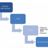 The article is more than interesting to give the reader an idea of how to start working with INSPIRE, starting with the configuration of the ATS - abstract test sets, their coding and requirements, continuing with the ETS - executable test sets, development tests - Test Lineage, Test Encoding, and Test Bounding Box, as well as the results obtained.
In addition to the reviews of the aforementioned articles, the other works that this magazine presents for this volume include:
- Valencian Toponymic nomenclature
- Geolake Search (the future of the IDE is in improving its catalog)
- On the status of official place names in the Balearic Islands: the Nomenclátor de Toponymy of Menorca and the future Geographic Nomenclature of the Balearic Islands.
As a first, they have announced the Geobloggers in its second edition, which will take place in June of 2019; event that Geofumadas will support again -this time in person-.
About Mapping
The magazine Mapping, is a Hispanic reference in scientific publications. With 28 years disseminating works and research on issues related to the area of geomatics, infrastructure, geospatial data management and significant developments that occur in this context.
“Since 2013, the current editorial team has defined a new strategic line for MAPPING. It has been chosen excellence and prestige, pretending that the magazine is one of the largest repositories of information and news in the sector and a link between private companies, universities and public organizations that develop projects, teach and disseminate Geomatics and its applications in the different areas that make up the Sciences of the earth."
We recommend going to the website of the magazine Mapping, there they will be able to have access to all their bimonthly publications.