Ten main reasons for making territorial data known
In an interesting article by Cadasta, Noel tells us that while more than 1,000 world leaders in territorial rights we met in Washington DC in the middle of last year for the Annual Conference of the World Bank Territory and Poverty, the expectation that exists regarding policies in terms of data collection to measure global progress towards documentation and the strengthening of territorial rights for all, women and men.
It is fundamental for us to recognize and also discuss the enormous potential of these same data, when they are made public and accessible, to empower communities.
When governments make public their data on land use, including rights and concessions, conservationists and indigenous communities can see which lands are protected and which lands are under threat. Farmers can gain confidence by seeing that their rights are properly documented. Banks can confirm who has documented rights and grant loans to support the purchase of better quality seeds and fertilizers. And agricultural extension agents can identify and support the sustainable use of their land by small farmers and indigenous communities.
Currently, we are far from this objective. The rights of 70 percent of land in emerging economies remain undocumented. Documentation on land and resource rights is often outdated or incorrect. Critically, these records are rarely accessible to the public. In fact, according to the Barometer Report of Available Data, data related to land are among the data sets least likely to be publicly available. The report maintains that the territorial data are,
"rarely available online, hard to find when available, and quite often behind paywalls."
The so-called "Payment Walls" limit the number of businesses that can build services based on information. And it reinforces the status quo of those who have power derived from access to information and those who do not.
As progressive governments and the international development community use new innovative technologies to document and strengthen land rights, they should analyze and evaluate, at the start of their activities, the benefits and risks of opening up much or all of this. information to the public.
We recognize that best practices can not be based simply on protocols in advanced economies. Releasing the name of an owner in a highly developed and relatively equitable country can help prevent corruption. But revealing the same information in a country with documentation of less formal land or with high rates of inequality may result in the dispossession or displacement of vulnerable communities.
That said, opening all or some of the data to the public can not be ruled out immediately because it is considered too risky.
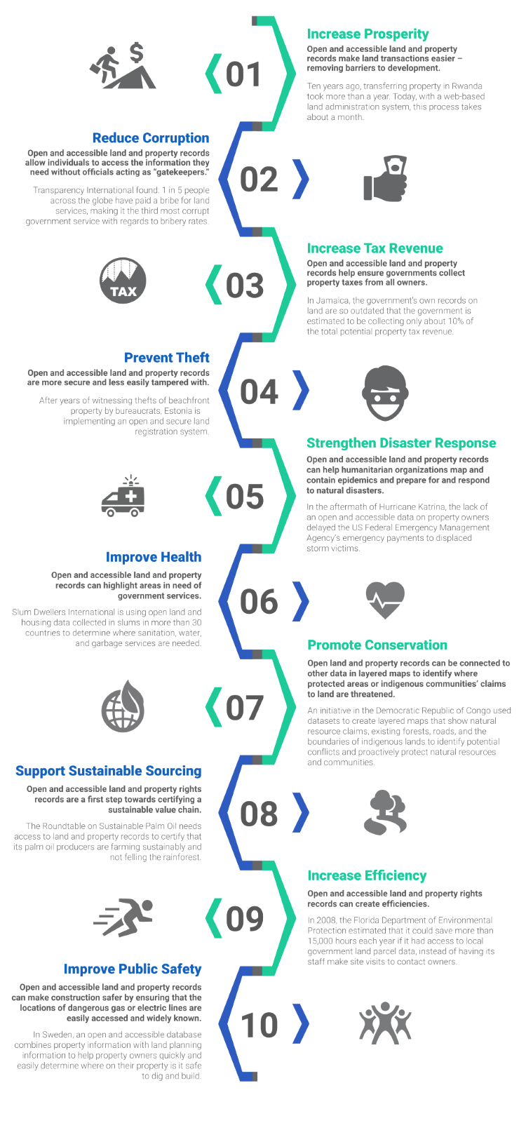
There are compelling reasons to open land records, as appropriate, to the public. The infographic shown below shows ten reasons:
- Increase the prosperity and development
- Reduce the corruption that occurs when carrying out procedures
- Increase tax revenues
- Avoid theft
- Strengthens the response to disasters
- Increase the health of the population
- Promotes the conservation of the environment
- Supports sustainable management
- Enhance the efficiency
- Improve public safety