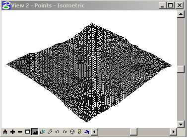
Make a digital terrain model (MDT / DTM) with Microstation and fit an orthophoto
Previously we were seeing how an MDT was done, and contours With AutoCAD to generate contour lines.
The ideal program to do this is GeoPack, from Microstation which is an equivalent to Civil3D from AutoDesk, it can also be done with Descartes, an equivalent to AutoCAD Raster Design. With these programs a stack of steps is saved but in this case we will only with Microstation V8.
1. The source file
We will use a file that already has a mesh of points in three dimensions, called 220_Points.dgn, we had previously talked about how you can import a mesh of xyz points from a box Excel to Microstation. We navigate and open “points” as the active model.
2. Generating the terrain model
- We created a new layer called DTM
- Choose the color and type of line
- We do the active level
- We select all the points and type in the text command bar (utilities / key-in) “mdl load facet;“, without the quotes
- Then in the following box we choose the tab XY Points and activate "Expand to Rectangle”, to mark a fence where we want the system to triangulate the terrain model
- Now we press the button “Triangle XY Points”

- An alternative is to use this combination of keyboard input: mdl load facet;. This will produce the same results, removing the requirement to open dialog boxes. It is clear that this keyboard entry will use the current state (on/off) of the “Expand to Rectangle”.
- During the generation process, MicroStation will also open its small text window and display three values preceded by the following letters:
V - The number of vertices in the resulting element.
F - The number of faces or triangles in the resulting element.
C - The number of output mesh elements connected. For the triangulation process, this value should always be 1.
3. Configuring Lighting to Render
We are going to do a rendering of the terrain, before putting the orthophoto on.
In order to obtain a better rendering of this particular model, we will first adjust the overall illumination.
- We select “Tools / Visualization / Rendering / Global Lighting” and in the resulting dialog box we adjust the values so that they match the following graph.
- To render the surface, from the same toolbox, select the “Render” and adjust the values as follows:
Target = View, Render Mode = Smooth, and Shading Type = Normal.
Enter a point in the isometric view and admire your results.
4 Loading the raster image to microstation
- From the Raster Manager, select “File/Attach” and select "220_Image.jpg”. This image is georeferenced, so make sure to uncheck “Place Interactively” of the “link” dialog box.
We obtain the following data of the properties of the image:
- We return to the reference settings through the Raster Manager. We navigate to the tab “Location” and note the following data:
- Length - This is the size of coverage that has the image, 5,286 meters wide and 5,228 meters high.
- Pixel Size (Pixel Size) - This is the pixel size, in master units. Our image has a pixel size of 1 meter.
- Origin (Source) - This is the XY location in the lower left corner of the image. So the lower left corner of the image is positioned in XY = 378864.5, 5993712.5
5. Creating a material based on Aerial photography (Ortofoto)
The strategy of creating materials is old in Microstation, as for example to make transparencies; in this case we will use it to make it look like the material we will use to render is the orthophoto as other images in the form of a patron are used.
- From the toolbox “RenderingTools”, we select “Define Materials”.
- When you first access this dialog, MicroStation will populate the left side with an entry that is equal to the file name. This entry is the beginning of a material table (aterial table) which is a file with extension .mat. A material table stores material assignments to items in a file that are at specific levels and also have a specific color.
- From the menu bar, select “Palette > New”
MicroStation responds by adding “New Palette (1)” under the table of materials. - We rename this as “PhotoDrape” selecting “Palette / Save As”, or by right clicking on the entry and selecting 'Save as of the list.
By doing this, MicroStation creates a palette file, which has an extension .pal.
- To create a material we activate the button “New material” and we rename ” New Material (1)” as "Aerial"
- To assign the aerial photo as material, click on the small icon highlighted in the graphic below and select “120_Image.jpg”.

- Now we apply the data we previously obtained from the image:
- “Mapping” to "elevation drape
X Size = 5286 and Y Size = 5228
Offset X = 378864.5 and Offset Y = 5998940.5
- We close the “pattern” dialog and save the changes by pressing the ““Save” in the “Material Editor” dialog box.
6. Accommodating the Aerial Photography (orthophoto) to the DTM as render
- We close the “Material Editor” dialog box and select “Apply Material” from the toolbox”“Rendering Tools”.
- We checked to have the correct palette and selected material as shown in the following chart.
- We press "Assign by Level/Colour” and select the mesh element that represents the terrain.
- From the toolbox “Rendering Tool, we select the tool “Render” and adjust the values as follows:
Target = View, Render Mode = Smooth, and Shading Type = Normal. - Now we activate the isometric view and that's it.
For this post we used a procedure shown by Jorge Ramis in an old page of Geocities that is worth rescuing because one day these Yahoo disappears this service, this was translated from Askinga.
Most recent versions of Microstation have functionality to do this with images of Google Earth and also Bentley has applications with specific potential for the handling of digital terrain models.


Very good tutorial, I get a question, could you do the reverse process? that is, from a triangular terrain could the curves be extracted?
A greeting and thanks
Only with Microstation you will not be able to, for that you occupy Bentley Geopack
Watch this article
http://geofumadas.com/crear-un-modelo-digital-tin-con-bentley-site/
SOME TUTORIAL REFERENT TO GENERATE MDT WITH MICROSTATION V8 MUCH THANK YOU GREETINGS MILAN MARTINEZ
congratulations very interesting but I only manage sitework and microstation I want to generate an MDT URGENT HELP ME
PLEASE HELP ME TO MAKE MDT WITH MICROSTATION I'M URGENT I'M STANDING AND I NEED SOME HELP FROM SOME FRIEND OR COMPANY MUCH AGRACEDERE GREETINGS MILAN MARTINEZ MARTINEZ LA PAZ-BOLIVIA
Chapeau !!
Very good tutorial!