
Where to find maps of Honduras
Often people are looking for cartography of their country, the institutions associated with the territorial administration, whether at the advertising, depository or constructive level, usually have places where they share their data. In this case I will talk about Honduras, because Google Analytics says that there are Hondurans browsing this site for reasons like this, and because they associate the Alvarezhn with Honduras, hehe.
Although there is a lot of data in government institutions, the place where it can be found ... and it will be possible if they continue to grow is:
The National Territorial Information System (SINIT)
 This instance, which although its creation is recent, has a lot to offer in the future, as it is the institution authorized by the land use law to publicize cartographic information of general interest, as well as leading some commissions, including the Interagency Data Commission Space (CIDES). With an adequate budget and sufficient leadership among partner institutions, it could become the right arm for publication purposes of the National Geographic Institute, where there is a lot of enviable technical and regulatory resources at the regional level.
The SINIT does not intend to be an instance to create cartography, but rather to regulate the action of the institutions that are “active partners” and that do create and update spatial data. The main ideal is the same as that of several Latin American countries: to avoid the duplication of public or private investments in the collection of information that already exists, which, if used well, can lead the country to a well-integrated territorial management.
The catalog
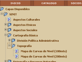 Although SINIT is geared towards an Intranet for active partners, some of the development that has been done for the web can be accessed via the Internet. Among others, the catalog stores the information in the following categories:
Basic cartography.
Physiography and Natural Resources.
Infrastructure and Social Equipment.
Social and Economic Aspects.
It is a bit poorly designed (in terms of aesthetics) and because it is governmental it tends to be down from time to time or its links remind us that someone has not uploaded some services, but hey, I hope they continue. When choosing the layer, (it is supposed) to display the map as an image, with captions and frame.
The viewer in IMS
In this they have stopped, not because they can not start to walk what we see took a few days nothing more ... and although they have not done much more at least allows the basics of the service ... and especially the download of layers .shp quickly.
By choosing the layer and level of coverage that can be national, departmental, by basin, etc. A link is activated on the right that says “Open HTML viewer“, which displays the layer in the form of a map service, implemented in ArcIMS and through javascript routines.
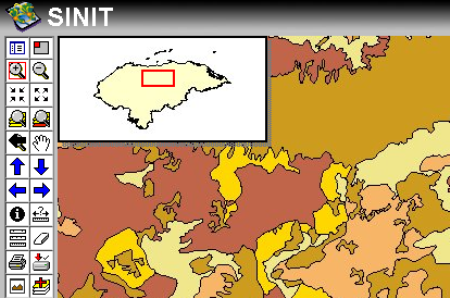
It has the basic tools of a development with ArcIMS, with the minimum template but its functionalities allow to load more layers with the last button, and to display basic info (although with bad taste of deployment)… but do not lose your attention to the Download icon, because with this functionality you download the visible layer compressed in zip format. The compressed files have the .dbf, .shp and .shx; all this cartography is in UTM Zone 16N WGS84 in case you cannot find a reference in the metadata.
So if you want data from Honduras in .shp format, this is the place. With a consultancy of about three months, a creative with good taste and a couple of developers, the other layers (cadastral, raster and territorial ordering) can be integrated ... and surely it will be able to become a good geographic portal that is sorely needed our Hispanic countries.
So cheer up, guys ... if all the countries made this effort we would have better opportunities to get out of underdevelopment. I also admit that it has been good to enjoy its landscapes, to have made good friends and to take many photos in my travels through its picturesque municipalities.
Some of these efforts were abandoned, in 2010 they are retaken within the framework of the Secretariat of Planning, then they are being continued by the General Directorate of Land Management.
Also on the Cenrut portal you can find Maps for Honduras GPS And Central America.


Hi, could you give me a number to request a map or what is the procedure
I request help to obtain the map of the municipality of ceguaca Santa Barbara
In fact, it seems to be in maintenance.
There is nothing left to wait or go to the institution (Teguicgalpa, Honduras)
Greetings, try to enter the website and is under repair, could help me by providing information on topographic maps of Honduras. Thank you
Thank you very helpful!
It is true what expresses OLVINA because I have to teach geography in basic education and MEDIA and it is unfortunate that even in the maps that are on the web is with shameful errors and in the books dis that new given by the secretary of education They also appear to be murdering the departmental, national, regional and world geography, and this is due to the fact that instead of using cartographers, they employ map makers, not that they require military, but that economic and professional support is required, if there are In the country, but since they are not politicians, they do not hire them, and on the other hand they take conscience of the Cartographic Character, because it deals with national security and not with simple maps: it is geopolitical.
IN HONDURAS NO OFFICIAL CARTOGRAPHY EXISTS, THE POLITICIANS WHO ARRIVE ONLY ARE WORRIED TO BENEFIT THEM.
THE ANCIENT IGN DOES NOT EXIST, THEREFORE GEOGRAPHICAL PRODUCTS ARE NOT PRODUCED.
THE PRECISION THAT EXISTS OUT OF TOLERANCE, IS NEEDED TO PRIVATIZE THE PRODUCTION OF CARTOGRAPHY-
THE BEST TIME OF THIS INSTITUTION WAS WHEN IT WAS DIRECTED BY MILITARS.
MR. PRESIDENT LOBO DO SOMETHING FOR THIS INSTITUTION, IT IS IN INTENSIVE CARE.
THE SALES DEPARTMENT OF IGN, SAYS THERE IS NO.
THE PRODUCTION TIME OF A CARTOGRAPHY SHEET, IS THREE YEARS AND THE CORRECT TIME IS OF 6 MONTHS, THAT INDICATES THAT THE ONLY SHEET WHICH IS PRODUCED WHEN THE PUBLISH IS ALREADY DISAPPOINTED.
Hello how are you I lived there with my parents I love you so much mariana