
Download the UTM grid of 1: 50,000 sheets from your country
The 1: 50,000 sheets are well known in the cartography of many countries, initially they were built with Datum NAD27 for America. In this case I have generated them in WGS84; It is wrong to believe that they can be changed projection just by moving a vector as some people used to for small regions.
If you remember, before I had uploaded the zones, now I have uploaded the same zones but with the grid of 1:50 sheets, making the clarification that it is called 000:1 sheets because this is the dimension used in some countries for printing However, the ideal name for this cartography would be sheets 50,000'1” by 30′

These sheets are made from the geographical coordinates and are 1'30” long by 1' latitude, which makes them straight segments that build arches that close from the equator as they approach the pole; this implies that within a zone there is not a single vector of these that has the same angle of inclination.
This is why these sheets should be constructed from geographic coordinates, see this example:

Using the leaf at the right end of the 14 zone on the south coast of Mexico is approximately 26,696 meters long at the same end, but on the Atlantic coast it measures 26,171 meters, since it is closing at greater latitude.
For my last year, it was necessary to create at least a couple of these areas to be able to explain how they work on map scales. So, I had to turn to what I had at the time; and that by the way does it very well:
How to create the grid
Using Manifold GIS is done in just two steps:
1. Create a new layer
File / create / drawing
Then we assign projection, right click on the "drawing", "assign projection", and choose UTM, zone 16, North
2. Create mesh
View / Graticle
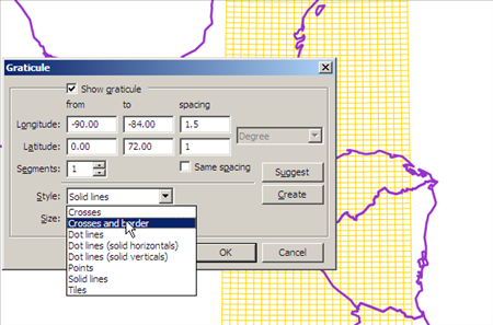
I choose the grid of zone 16, which goes from longitude 84 to 90, I leave it in the negative since it is west of Greenwich. As far as the latitude, from the equator and since I don't want it to reach the pole, I choose from zero to 72. To the right I assign every time I want the mesh, which is the dimension of the leaves 1:50,000, these measure in my case 1 '30” of longitude and 1' of latitude: to write 1'30” I divide 1.5 by 60 which would be 0.25 degrees and 1/60 which would be 0.166667 degrees.
It also gives me the option to choose if I want shapes, points, crosses ... I choose lines
then I click the “create” button and “ok”
Creating the other zones is a matter of changing their projection. Once the UTM zones have been converted to Google Earth, this is how they look (hiding zone 16 which was the one I created initially).

There you can see that:
- Mexico is in zones 11, 12, 13, 14, 15 and 16. All in the northern hemisphere.
- Guatemala and El Salvador in the 15 and 16 zones
- Honduras, Nicaragua and Costa Rica in the 16 and 17 zones,
- Panama in the 17 and 18 zones
- Colombia in the 17, 18 and 19 zones, with the complication that it has both in the northern hemisphere and in the southern hemisphere,
- Peru in the 17, 18 and 19 zones,
- Bolivia in the 19, 20 and 21 zones,
- Argentina in the 18, 19, 20 and 21 zones,
- Chile in the 18 and 19 zones
- Brazil in areas 18 to 25 in the southern hemisphere and 19 to 22 in the northern hemisphere,
- Venezuela in the 18, 19, 20 and 21 zones
- Uruguay in the 21 and 22 zones,
- Paraguay in the 20 and 21 zones,
- Ecuador in the 17 and 18 zones.
This shows the UTM zones with the same Europa grid, from the 27 zone to the 37 zone; all in the northern hemisphere.

If you do not have GIS Manifold, here you can download the kmz file, which you can open with Google Earth:
If you are interested in having all the zones, in the following link you can purchase a file that contains all the UTM zones. Includes the zones:

you can acquire it with credit card or Paypal


It is not something as simple because it is not a grid. At the country level there are lines in which curvature is displayed. Besides, if the maps are not on the same scale it is difficult to make a template to trace it.
One way could be to make a template in transparent plastic, with the grid, traced on a map of INETER, and with this map to other maps, which are on the same scale; could be added new tricks such as identifying points in the geometry of the borders where intersections can be identified with the parallels or meridians, and if it is for school children, including assuming as a grid a grid of horizontal and vertical lines (which are not)
Good evening from Nicaragua, I am a Social Sciences teacher at first and that includes teaching Geography classes in my country, but I am curious to know how to establish the grid on a printed map that does not have it, and I need to teach to know the procedure for later transfer knowledge to the classroom. Thank you
There are the 15 and 16 zones. Among these areas is Guatemala
Might you help me; I need this kind of grid for Guatemala.
what country?
I ask for help to know how to list the quadrants of my country
Thanks for the data, I was very useful for my purpose of understanding the use of meshes of zones.
thanks a thousand ...
When loading the kml in google earth I do not see the grid only a horizontal line ...
Thanks friend! Just what I was looking for, hugs from Argentina
Ready, there you can download them.
17 to the 25 of the southern hemisphere are included in kml format, apart from a dxf file.
All the best
Mmm, I will take it into account, hopefully and not in the same stress conditions as this post was. Just to remember it gives me shivers.
Greetings you could upload the grid of the south emisferio please
The example that I show you in this post is done with Manifold GIS, and it can be exported to kml.
You can define it every few degrees or distance in meters, and if you want to make lines or shapes.
HI, I'm looking to create a .kml mesh with specific spacing (eg, 1.25 degree x 1.25 degree, 1 × 1, etc…). I tried using zonums online software and it doesn't work for me.
Any other tools I can use?
Thank you
To see it with AutoCAD, you must convert the kml to dwg.
How can I visualize these meshes in autocad, my friend?
I WORK WITH TWO PLATFORMS MAPINFO 10.5 AND ARCGIS 9.3 but lately I HAD PROBLEMS WITH ARCGIS 9.3 and 9.2 IN DIFFERENT MACHINES WHEN GEORREFERENCIO A RASTER THIS saved it with georeferencing BUT WHEN I GIVE PROPERTY NOT ME ACKNOWLEDGE NINGUAN COOREDENADA SPATIAL AND NOT TO BE MUST THIS PROBLEM LIKE TO KNOW IF ANYONE CAN HELP ME
Hello g !, you can help me export my files to kml, I try to change the coordinate system with Bentley Map but in my country El Salvador is in quadrant 16 but as it is small, we work with a division of quadrants, how can I do in this case, since when I export, the files in the Pacific Ocean fall to me, like a kilometer and a half to the south. Thank you
Look, I recommend the Application manual And videos of AUGI MEXCCA
my dear friend you will not have a fast course of civil 3d since it is the one that I am husando at the moment
Roads, tunnels, hydroelectric
If you can help me I will thank you in advance
Bandido_vallejo_1955yahoo.com
From the chaotic city of mexico df
AND THE FOURTH URNA IS A LITTLE RARE THE THING, I AGREE IN THE CONSULTATION AND THAT THE CONSTITUTION IS REFORMED (THAT HAVE VIOLATED IT SEVERAL TIMES), BUT I DO NOT WANT TO CONTINUE THE CURRENT PRESIDENT AND ITS CABINET
ALREADY SUBMIT THE DOCUMENTS I HAVE HOPE TO SERVE, I CAN UP AND HELP MANY COLLEAGUES
I already sent it to upload it
Editor (at) geofumadas.com
Your mail master
Honduras; Zone 16 and 17, of course it is there.
Greetings to the fourth urn, hehe
Master Alvarez, I'm from Honduras. Is the mesh there?
I need this program and CAD 2009, because I am a student of design design, it is a very good course that I am doing but I lack the CAD program and it costs me a lot to settle knowledge because of the lack of these programs, as many prograna in free foma, envienmen please CAD and Maya leaves 1: 50,000 to study, I remind you that I am unemployed and all I have to pass the bad weather of unemployment is to study, it's my best ansiolitico.muchas thanks for helping.!!!
THANK YOU, IT'S A GREAT CONTRIBUTION …………………….