From Kml to Geodatabase
Before we talked about how Arc2Earth Allows you to connect to ArcGIS with Google Earth, upload and download data in both directions. Now thanks to Geochalkboard we know how to import data from kml / kmz files directly into an ArcCatalog Geodatabase.
From the menu of Arc2Earth, import / import kml-kmz is selected, then a panel appears where we configure the form of data import:

Then the panel shows in the “general” tab The options for defining whether the file supports GeoRSS standards.
If it is entered in a Personal Geodatabase, the destination of the mdb base is chosen.
In case of having an Enterprise database implemented via ArcSDE, the string that defines the name of the database, user, password and server path must be written. You can also configure characteristics of the destination Feature class, in case there are rules configured to interpret the style configured in the kml.

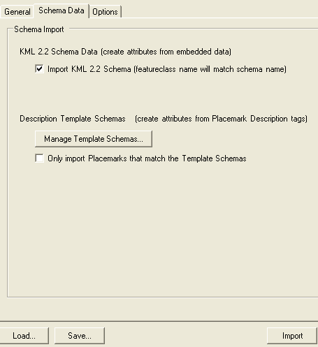
In the “schema data” tab, You can specify if the kml file has kml 2.2 language attributes, where the xml structure allows you to define more specific attributes for dome labels, line styles and complex shapes. These can even be defined as templates and import only those objects in the file that match the template ... that way we can define filters for what we do not want to import.
In the "options" tab, You can specify if we want the imported data to replace the existing content whose characteristics are match (replace), if we want to replace everything that exists or if we want them to be added (append).
Here, too, you choose the destination where the overlays of terrain will be stored.

Some links of interest:
Video illustrative of how the import works with Arc2Earth
Courses Available from the use of Arc2Earth