
How to Download Images from Google Earth
It is possible to download one or more images from Google Earth, in mosaic form. To do this, in this case we will see an application called Google Maps Images Downloader In the newly updated version.
1. Defining the zone.
It is appropriate that you make a grid in AutoCAD or ArcGIS, and then export it to kml, because it will allow you to have better control if you are going to make large downloads.

2. Entering parameters
The system requests the ends of the complete quadrant of the area that we are interested in downloading, for this it is necessary to enter the 4 data in decimal degrees, not in UTM coordinates, before we had spoken How it is configured that view in Google Earth. The system also has a converter from degrees/minutes to decimal degrees in the “tools” menu.
Once you have provided the coordinates, you must enter the zoom, this is the approach level, that graduated scale that is at the ends of the zoom in Google Maps; The maximum approach is 18x (in the shareware version only 13x is allowed)
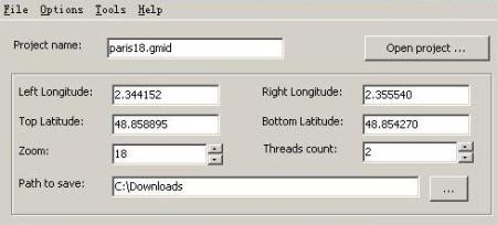
Then you enter the amount of thread downloads, the maximum is 64 and you choose the destination folder of the images. These will be stored in bmp format, and a text file with the name of the project containing the coordinates of each image.
3. Joining mosaic images
The system has a viewer to see all the images in one, you do this by opening the project “file/open project”
To join them in a single image you do it with “tools/combine images”, you choose the project and the destination of the resulting file. This process can consume considerable resources if the number of images is large, I recommend that you do the test with small amounts so that you know the performance of your computer, because even if your ram memory is high, it can be slow due to many installed or poorly uninstalled programs.
4. Georeferencing the image of the united mosaic
Remember that the image is in a .bmp format, to georeference it I recommend you to see the previous posts where I spoke how to do it with AutoCAD, Microstation y manifold.
5. Precautions or observations
- It is not advisable to make massive captures, because Google banea your ip when detecting the consecutive discharges of adjoining zones. In case of this the system will report it, Google takes about 24 hours to reactivate a banned ip although you can change it in and continue (to change it you must go to network connections, right button on the active connection, properties, tcp / ip protocols , And set up a different ip). They can also be saved as projects with .gmid extension, so that downloads can be done partially, stopping the session and continuing after a pause.
- In case your connection has a proxy, you must configure it in “options”
- The license is shareware, and can only download up to 13x, the paid license is worth $ 25
- This download is for images, you can not download maps or hybrid images
- If you want to know how accurate the Google Earth images are Disengage for yourself
- Here you can download Google Maps Images Downloader
What, has anyone seen any other application that does something similar?


Good afternoon you can use the CAD-Earth, with autocad or briscad platform, import image from Google Hearth, as well as images from other dates already geolocated
I already tried the application but it only generates me 1 image and blank. what may be happening
The other program that does that is PlexEarth
Another tool that does this is Plex.Earth
What you must do is export the file to kml, and this way you will be able to open it with Google Earth
Hello
Recently I found myself with this wonderful page, of which I have cleared some doubts; but I would like to know a bit more about how to import the mesh from autocad to google eart.
Note: the version of autocad in which I work are: autocad 2007 and Civil 3D 2008
Garcias
Hello Adrian, Stitchmaps also exists, it does the same function.
http://www.stitchmaps.com/
Too bad the site is stoped ... will there be another program to do this?