Why thank Neogeographers like Google
This is the name of the interview that Eric Van Rees made with the important men of three outstanding companies in the geoinformatics technologies:
- Jack Dangermond, President of ESRI
- Richard Zambuni, Director of the Geospatial Bentley
- Ton de Vries, Executive of Bentley in the line of Cadastre and land development
- Halsey Wise, President and CEO of Intergraph

The document is interesting, and it comes at a time when the evolution of desktop technologies (Desk GIS) has evolved considerably towards the web (web GIS) and its integration with CAD has progressed a lot. Apart from the growth and consolidation of the standards of exchange and web integration.
 The interview is based on a series of questions, in which each of the participants raises the vision of their company against the market trend. These are the questions, translated not literally:
- What will be the role of GIS specialists in the future? Will they have more specialized in computer science or will they continue to consider themselves experts in GIS? Or perhaps we need specialists who have multiple mastery of technology, economics, social sciences and legal applied to geoinformation?
- Do you think desktop-based GIS tools will continue or be replaced by server-based tools?
- Does your company have a responsibility to the global crisis? Does this include opportunities to apply GIS? And how?
- In Europe the GIS industry is based on INSPIRE, GMEIS, SEIS and GALILEO at the moment. In the United States this does not interest them, I have the impression that here the industry is based more on what Google, Microsoft and Yahoo do and how to integrate with them. What's your opinion about it?
- The integration of CAD with GIS is a capacity that is becoming more and more important every day. What is the current solution that your company has now to achieve this GIS-CAD integration? How do you see the future: will we continue to see these two specialties or do you think the time will come for both to have full integration?
If you want to see it, you have to Consult the June issue Of the magazine Geoinformatics, which brings articles of interest such as:
- Sonar data for the seabed
- Map of land use in Australia
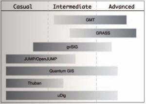 Mapping the world with free GIS software. This is the continuity to the line that they brought from the Three previous versions about open source GIS tools. The article is interesting, based on the book by Gary E. Sherman, with that name, see the graph and the position they give to gvSIG at the user specialty level.
 - AutoDesk, saving cities from overpopulation
- Cicade & DIMAC Systems.