
Finding maps in vector format of a certain country could be the urgency of many. Reading the forum Gabriel Ortiz I found this link that is interesting because it not only offers maps in .shp formats, but also kml, grid and mdb.
Is GData, A service promoted by the International Rice Research Institute, is free and seems to be from around the world.
Maps can be searched by country,
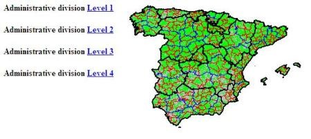
This is an example, in the case of Spain, if we want to look for maps of the administrative division in kml format the result is:
- Map at country level
- First division (Autonomous Communities)
- Second division (Provinces)
- Third division (Counties)
- Fourth division (Municipalities)
It's that simple, just to download. Although in the case of .shp it is not required to download them separately, but rather the compressed file includes the .dbf and .shx files; and in case of geodatabase the .mdb contains the feature classes.
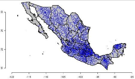
This is the example of Mexico and Peru, to give two more examples:

Available data include:
Vector format:
Shape files, .kmz (for Google Earth) and .mdb as geodatabase
- Administrative boundaries
- Hydrology (Inland water)
- Roads
- Railroad lines
Raster Format:
Grid with 30 seconds resolution
- Elevation, SRTM30 dataset
- Vegetable cover
- Population density
- Monthly weather data
You will have to corroborate the accuracy level of your country, in the case of raster data, the size of a 30 seconds pixel near the equator walks by 0.8 square kilometer, but as the latitude moves towards the pole, the size is less.
The website is GData.
Another way to find maps is D-Maps.


Are they data for public use? Can companies use it by saying how they acquired it?
Editable Electoral Cartography Mexico 2012 SHP and TAB
Hello, for those who are looking for the editable electoral cartography at the Mexican Republic level of the 2012 year, you can contact me via email, there are more than 40 layers, among which are those of States, Municipalities or Delegations, Federal electoral districts, electoral sections , neighborhoods, schools, hospitals, shopping centers, airports, roads, blocks and more. I use them in shape format for arcview or arcgis and in tab for mapinfo.
Ckr.deluxe@gmail.com
Of course, the data have a small scale, but they are useful as for integration of regional IDEs.
I ALREADY reviewed the page, very general for my use but light and practical for international inquiries ...}
salu2