
Where are the users of Manifold GIS?
Some time ago, a Dutch technology guru told me this sentence:
“Honestly, I'm amazed at what the Manifold page says. What happens is that I have never seen it in operation on a machine "
This week, Patrick Webber -of Spatial Knowledge- has made a reckless statement that has surely made the very beards of the creators of this tool tremble. Although they ... do not believe they have a beard, but I bring it to reflection to follow up on my Predicted — Tions this year.
What is the Manifold Problem?
Patrick is based on the theory of Geoffrey A. Moore, in his book "Crossing the Abyss”, Which outlines the life cycle that occurs in the adoption of computer products. One of those crucial stages is called Abyss (Chasm), where the software needs to sustain constant growth while being embraced by early-willed buyers, to avoid the risk of never reaching a representative segment of the market.

Patrick speaks clearly of how satisfied he is with the innovative level of Manifold's creator company, the pricing model, and the user collaboration on the forum. But it criticizes a quite delicate issue in the business format, because in that insistence of not having resellers or representatives other than on its own page, although it contributes to having a Acceptable price, It may be a funnel that is stopping growth.
To do this, it brings Manifold forum, where we show what we all suppose: People who have an 7x version find no reason to switch to the 8x and are waiting to see what happens with the 9x dream to decide whether to move or not. It can be total satisfaction, but if migrating represents only $ 50 per license, we would have to think about other drastic implications such as the irreversible format change, since -as an example- you cannot pass a .map from version 8 to 7 and it implies migrating all the existing licenses. What not to say about the built development or user manuals, which surely must have been elaborated because Manifold only offers the “help me"In his own way.
What could be happening, then, is that Manifold will continue to be that pretty rocket ship for geofumers but it can never have an appeal to ordinary users. They can justify themselves in whatever arguments they want -How sure are there- but scratching the nuts to ESRI requires more than having better software than ArcGIS -Which in many things is and many are-. You need to build community, have allies who also win, a geographic location in another language, non-token-based support, including "tech evangelists" and ironically even piracy.
At no time is the software demerited, but all at one time we have worked in normal companies, which to make a purchase require a human contact, from there a process of support, training and license renewal (all paid of course). the same Bentley Systems It has its barrier for managing its sales regionally, which works but delays transactions that, because they are not local currency, usually have an extra procedure. The case of Manifold should not say, that the purchase must be made online, with a credit card, starting with the fact that no average municipality and not all companies have one; And, for those of us who have experienced it, we know that purchases via bank transfer have their level of complexity in conventional environments.
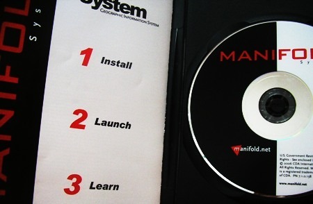
Ah! I forgot about the support. A Manifold license comes with two Tokens, for only two questions to support. If you want more, pay for it; the idea is not bad, but it is necessary to see if it is functional. It is not that Chinear To people, but the three words of invitation when buying the software are not enough: "Install - Launch - Learn ", Because it will be difficult to convince a boss that in the operational plan of the new year it is necessary to leave a budget for 15 Tokens Or pay the publisher of geofumadas for a chat support :).
Bottom line: Manifold is great software, but it's not growing. Although version 8 already exists in torrents, a sign that it is becoming popular, very few people on the web are talking about its capabilities, less about their satisfaction with the customer service model. If it continues like this, it will remain a toy for an exclusive group of experts and will lose popularity as a practical solution for GIS - which is what it is. And the final chapter of that type of novel, we all know it.
What to expect
 Well, on the one hand Manifold's friends lower their arrogance. In particular, without demeaning the software that seems wonderful to me, that I use constantly and about which I have spoken up to my ears, I have seen responses to queries made in the forum that do not have the warmth of a salesperson but rather a president of the Bolivarian Alliance what does it say "This is my government, here I am, and if you do not like it, change the channel".
With apologies of course, for those who like that type of treatment and who visit me from the countries of the southern cone. But if in Gabriel Ortiz's forum –which is free- we have lost friends due to bad answers, what not to say in a space where the creators of the software –that is not free- respond.
One day I questioned her Advertising department, Another su Business ethics, and today, I insist on what some say: A good technician will not necessarily be a good manager, a good genius is just around the corner from being a lousy businessman. There are specialties, and any tech guru who becomes a software vendor is going to need a basic customer service course and primitive lessons from their marketer on what doesn't come in the .NET API.
What will happen to Manifold? That definitely depends on its creators. In my opinion, I think Patrick's warning should have a positive impact.


Hehe, tell me that I've come to think like them.
From manifold I have been answered the same (could not be otherwise) with a very friendly but standard mail.
Thank you
I think you should buy the 8, because there is no security when the 9 will come. In addition, when a new version comes out there is usually a promotional time to migrate that costs only US $ 50.
Hello everyone
I have a question that I do not know if it might interest others.
Buy 8.0 manifest or wait for the 9 to come out?
I just changed computers and I do not know if I install my 6.5 version and wait for the 9.0 to exit or buy and install the 8.0.
I use it occasionally and, mainly, for map editing for hiking projects, with almost no analysis, although I would like to.
Thank you
Jerome
Hi all:
I have a problem with Manifold. I have sealed the surface of an area and I want to overlay the orthophotos, but for this I have to cut them one by one. Saving the manifold gives me an error:
CAN'T WRITE DATA TO STREAM
What I can do?
It does something, but not exactly connect it, but as an image import. Here is shown how . Another limitation is that it comes in black and white, although buying separately Plex.Earth itself can be in colors and with better precision.
If I'm not wrong, I think you can connect Autodesk Land to Google Earth. Autodesk Land has GIS functions.
Yes, It does to Google Earth, Virtual Earth, Yahoo Maps, and Open Street Maps, As a georeferenced layer (From images of course).
Also, once the image is displayed, you can give the "unlink" option, the image is stored locally, at a precision that can be established, and already georeferenced. It can be left inside the geodatabase (.map format) or exported to another format to store it outside and leave it as a reference (linked)
MANIFOLD IS CONNECTED TO GOOGLE EARTH AS IF IT WERE ONE MORE LAYER?
I forgot, a greeting to the readers' union.
hehe
Already the comments are longer than the same post.
1. Edition: the minimum almost the same (or less) than ArcGIS, in my opinion it exceeds gvSIG.
Geoprocessing speed, it is very robust. Even with the option of interacting with GPU In 64 bits !.
Layer management simultaneously, go well. In this even is rare its traditional logic, because a layer can have polygons, lines and points.
3. Interoperability… with databases and raster, it is great, both for georeferencing, storing, indexing and serving.
With standards, walk half short, wms (client / server) wfs (server only) this is very bad.
With common GIS vector data walks fairly good (shp, kml, xml, etc), although with the advantage that they must be imported into the gdb as a layer, linking only allows raster and databases.
In CAD it is limited, it does not advance much with recent formats of common use, dwg, dxf and dgn, hardly those supported by the open aliance, v7 and 2000.
4. The fourth point: totally uncertain, especially if they maintain that grudge towards high-cost commercial software, with which alliances must be made sooner or later. They attribute to that, the incompatibility with formats like dgn and dwg, always hiding that the monster software is closed and in many cases obsolete.
Not that you have to pay homage to AutoDesk, but macho, sooner or later you have to understand the customer and alliances are necessary. Its tone in referring to the competition, gives the impression that they are antiESRI, but they are not antiMicrosoft, by the way they read SQL Server, they only serve via IIS in what seems to be also antiLinux when you talk to them about Apache.
For those who develop applications is a great alternative, as far as I have spoken with users of Manifold, ALWAYS are SUPER pleased, like who has the most advanced telescope. But in this of software, you do not occupy to have the best telescope, sometimes it is better to have the one that all the others have, by aspects of sale of services, training and exchange of information.
Only because of the embers that you find with MANIFOLD, one is stung by curiosity. The truth is that licensing is affordable. You have commented on some tools that in themselves are worth the expense of purchasing the product. Doubts: 1. How about the editing tools compared to gvSIG-ArcMap? 2. Geoprocessing speed and management of many layers simultaneously. 3. Interoperability 4. Uncertain future, especially for the emergence and development of softlibre. Only with the first three convinced me, improving those of the mentioned programs I would investigate a little more about the soft.
Orderly…. difficult thing you ask friend. I swear I will one day, but for now:
As for giant software, the biggest contribution is the price model. That is indisputable, since from $ 235 to $ 900 Manifold does (almost or more) what you would do with ArcInfo, ArcSDE, ArcIMS, MapObjects, ArcGIS Server and a few other extensions. This does not include runtime licenses from $ 120.
As for free software, the battle would win by individual, but not collectively with the maturity they have achieved.
Perhaps what Manifold has raised expectations is his innovation to do things before others. Among them I can think of things like:
-Connect to Google Earth / Google Maps / Virtual Earth / Yahoo maps / Open street maps like no other has done, from there by 2006, being able to download the image as you would today with Stitchmaps.
-Integrate a very practical geodatabase (.map) format with which you can manage from the same software what it would cost you a good time to do with Mapserver + postgreSQL + gvSIG or similar combinations. With simplicity to integrate external data or serve wms / wfs.
- Read / write many databases natively, including 64 bits.
- Potential to interact with GPU.
-Control topological
-Geocoding
-Etc.
Not that these things are not done by others, it is that they have generally done it first. So, if we make a list of what others do and does not Manifold, there would be another list.
What happens is that being innovative does not seem to be enough if the other programs will one day do the same. Many of these innovations are attractive only to specialized users, with priority in the development and not in common operation.
Honestly, with the great giants (ArcGis, Autodesk, Mapinfo) and the great free software (qgis, grass, gvsig) by your side… What does Manifold contribute? Could you answer in a neat post?