
A standard model for the Cadastre
This name has a paper presented in the Third ISDE Congress, held in the Czech Republic at 2003.
| The authors, all of the ITC and the Department of Geodesy of the Delft University of Technology, the Netherlands. Although the link that I show (in English) has certain additional adaptations. |
|
 The document makes a proposal of how a cadastre model could be, seeking to avoid the duplication of individual initiatives; at the same time that the data interaction between portals can be less painful… it is good for me now that I am working on a concept document for the cadastre. This model establishes a series of data known as "common space" without limiting the particularities with the premise that it could be adapted to the different variants that exist in each country, territory, which include institutional makeup, levels of precision, and final vocation.
The document is very good, a great smoke, it is the result of the review of different models in countries such as Holland, El Salvador, Bolivia, Denmark, Sweden, Portugal, Greece, Australia, Nepal, Egypt, Iceland, and several African and Arab countries . In its introductory section it mentions the different initiatives that are binding, among them the OGC, INSPIRE, EULIS, ISO Standards, Cadastre 2014 and FIG standards.
Cadastral Domain Model (CCDM)
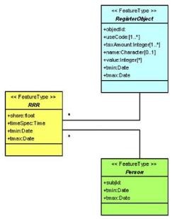 The document works at the level of UML diagrams different classes of objects, starting from the three main Cadastral figures:
- Object (Property)
- Subject (Person)
- Right (right or alteration)
This is the fundamental principle of any cadastre, which seeks to keep the relationship between people and real estate up-to-date through acquired rights, whether registered or in fact. Then detailed special classes are made for each of them, with specific colors that include:
- Topographical Classes
- Geometry and Topology
- Legal and Administrative Classes
- Control of historical changes
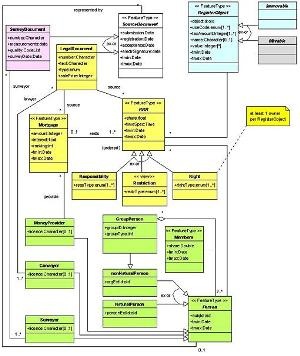 Then at the end they smoke marijuana, assuming how the objects could be handled in three dimensions and the legal space. Unfortunately, the Spanish version does not include the respective colors of the original document and the pixelated quality of the images is terrible, so I recommend having the English version on hand. Also the content in Spanish is extracted, and does not include topics like the examples built in gml.
The model goes a long way, since despite being the intention to comply with the declaration of the 2014 Cadastre referring to the death of manual cartography and long life to modeling, it transcends taking the limited term “cadastre” where the objects are the plots, to “ land administration” with the territorial objects as a center.
The fact that the TC211 standards of the OGC (Geometry and Topology) have been imported gives it weight with the OpenGIS context. But basically, its impact is in proposing how to take advantage of the demand for e-government and spatial data infrastructures, taking advantage of connectivity and information technology.
A great document, I recommend reading it and saving it in your collection of geofumadas because sooner or later you may need it.
Here you can download to Spanish version Of the Ministry of Economy and Finance of Spain.
Here you can download the English version of Eurocadastre, although some more extended details can be seen in the book "Cadastre 3D In the international context "
---
The document referred to here is a version 6, known as Moscow '06. It includes the additions suggested in version 5 that includes buildings within the RRR class and the PartOfParcel class is detailed separately. The first one presented in September 2002, 5 months after Chrit Lemmen got engaged at a FIG event in Washington.
For 2012 the CCDM is known as LADM, and it is a registered ISO standard. The LADM is considered to be an evolution of Cadastre 2014.


I am interested in the subject if you can send me information.
I am introducing myself to the cadastral issue, because I am receiving the professional surveyor course in Guatemala City, Guatemala, Central America .. If you can continue sending me information to my mail, I will always thank you, thank you.
To download it completely, right-click the links in the last two paragraphs and then choose "save link as" and you will have them in pdf.
Greetings, excellent do cumento, please send it complete to my email, thank you.