Urban sprawl, 2011 theme
The demographic theme will be in fashion this year -And the following- because there is not much to do to address solutions globally. This year's focus for National Geographics is precisely the world population on the eve of adjusting to 7 billion. The January issue is a collector's classic.

The Lincoln Institute of Territorial Policies has prepared several theses and research materials that come from one more study of 3,000 cities that exceeded the 2000 inhabitants in the 100,000 year.
The publication that I liked the most is the document called  Making space for a planet of cities. An interesting report that analyzes the past, present and future of urban growth worldwide. It proposes a new paradigm of how we should prepare for the growth of the coming years.
Great job of Angel, Shlomo, with Jason Parent, Daniel L. Civco, and Alejandro M. Blei. It can be purchased in print for US $ 15 and downloaded in pdf format for free (you only need to be registered on the page). For the year 2012 the publication of a material called The Expansion of Cities, Which will surely be an interesting proposal that should include the models of the Charter Cities, that reminds me of the principles of Facebook's CitiVilles and that it is dangerous to create new political crises because although it is an extremely interesting proposal, many see it as a new form of colonialism.
Another content of the Lincoln Institute, always in this subject is The urban expansion atlas. This is an invaluable collection of information available for download containing maps in image format, kml and xls sheets that served as the basis for the construction of the -and other- aforementioned document. There is also data in GIS format to be read from a GIS program.
This is organized into five sections:
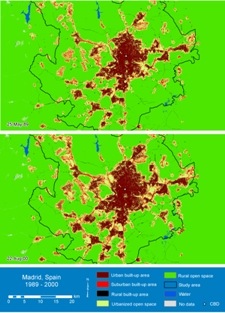
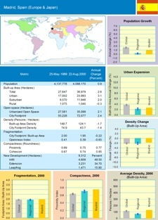
1. The first part, there are jpg images in the form of pairs diagrammed to print on posters. One image contains statistical and graphical data, the other maps of urban land use built with remote sensing techniques with satellite images in metropolitan areas of 120 cities in two periods: One taken around 1990 and the second 10 years later in 2000.

The upper map shows the location of the 120 cities, the colors are the regions as the study is divided. As an example I leave you the pair from Madrid.
 |
 |
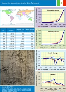
2. The second part Includes a population-based historical growth study of 25 cities, analyzing maps from 1800 to the end of the century just ended. These 25 cities are distributed, as shown in the following map: 7 in America, 4 in Europe, 6 in Africa, 12 in Asia and 1 in Oceania.

The images below are an example of the case of the metropolitan area of Mexico. On the left the areas covered by the urbanized zone from 1807 to 2000, and on the right are the population data, hectares covered, density graphs and a representative old map.
 |
 |
3. The third section It includes tables in Excel with all the data that support the work of the 15 and 120 cities. Exceptional, since Excel filters make it easy for us to see this data according to our interests.
4. The fourth section includes data to be viewed in GIS programs. Both administrative region geometries with layers .shp .dbf and .shx to see with any program, as well as .prj files for georeference, .img for raster display and .lyr to see the layer with theming and structure properties in ArcGIS.
5. The fifth section It includes the information of the 3,646 cities in an Excel sheet and also in a kml file with all the urban areas studied, to visualize it with a GIS program or Google Earth.
In short, a valuable material that can be very useful for students, public officials, researchers, planners and people involved in socio-economic development.
Both the atlas and the document provide a conceptual framework and, it seems for the first time, the empirical data on the past, present and future dimensions of urban areas in cities around the world. It opens the perspective of a challenge that we do not know how to tackle in the following decades.
For now I do not see if it is possible to buy it on a CD or DVD, as the download must be done individually.


