This is an interesting article by Regis Wellausen published in Home, which reminds us of the irreversibility of those statements of Catastro2014 raised by FIG twenty years ago, especially in relation to modeling as a replacement for traditional cartography.
The proposal of positional resolution replacing an aging paradigm.
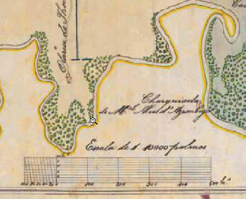
The concept of scale - The relationship between a measure in plan and its true size on the ground - It is part of the human DNA since the great navigations caused the dimensioning of the maps from 1.500. Based on the inherent “Graphic error", The technical standards for its production define, for each scale, the residual error that we must consider between the plant and the ground, in the daily decision making during the use of those documents.
In Brazil, the Cartographic Accuracy Standard (PEC), which is now a mere late popularization of Decree 89.817 / 1984 specifically designed for analog aerial photography, establishes three kinds of quality, and one cheaper, called Class C (which is the one that Always available), the residual error is 1,0 millimeters of the scale. Also, when "measured" on plants, our DNA saves that error in memory and, intuitively, the organic vector processor that we all put in the margin of error in the field. For example, if we measured the scale with an input segment with 1000 meters in an 1: 10.000 plant, we must have an account that we would find between 990 and 1.010 meters on the ground.
Scale in 1864: detail of the division plant of a plot in the Empire of Brazil.
The Digital Scale in the Digital World
The great truth is that we do not do these projects on static paper maps anymore and we do not care about their exact scale of printed end products, then no one else will measure with scales on them. What matters is only the quality with which they illustrate and / or document are our concepts and ideas. The manipulation of spatial information and operational end products are already and will be inexorably digital. In this medium, all the information - Which is necessarily georeferenced to a Cartesian coordinate system - is always analytical, which allows us to freely vary its scale with zoom and select the mathematical absolutism of any element with the numerical magnetism of the osnap command or equivalent - something unthinkable for 500 years !. Therefore, there is no more recurring error of our visual accuracy or design stability, basics of graphical error, neither when we read nor when we design. The only latent error to worry about is the recurrent method of production of spatial information used, whether it is vectorial (CAD, GIS) or matrix (Images), but this is not related to the "graphic error".
Positional Resolution
The term positional resolution is presented from the other "resolutions" enshrined for satellite images, such as the geometric, radiometric, temporal, etc., that was developed in the decade of the 90 to certify the cartographic precision of the forces extracted from Digital videography - a product that precedes previous high resolution images.
Positional resolution is defined here as the precision of the georeferencing of the image, that is, the difference of the position (coordinates) of any digital force in relation to its true position in the terrain or, more decisively speaking, in the detour -pattern of the differences between the support points used, in the image or the terrain. The positional resolution is applied with the same simplicity to qualify the vectorial information. In a topographic digital survey, for example, the positional resolution of the final product will be the standard deviation of the differences between the coordinates of elements, read in the software (CAD, for example) and later measured in the field (with GPS, for example ). If you are interested in the designer and the certainty that no element is closer to 1 meter of the future paths, when they are located, that is the positional resolution to be specified by the executor of the survey. That, in turn, will be free to choose the method of execution according to the technology used, plus it will always be or solely responsible for the specified quality.
As can be concluded, positional resolution can be used as a reliable parameter of the cartographic quality of spatial information in a digital environment, fundamental for decision making of the limits or potential of its applications. On the other hand, being a recurrent parameter of the productive method, positional resolution is intrinsic to the product and subject to the technical responsibilities of its executor.
This enables the recording of a Technical Responsibility Note (ART) and ensures it in its transition and use of third parties. At any time, the contracted positional resolution can be verified by measuring a position sample of well-defined shapes or elements on the ground. At the moment we already have several sensors, producing commercial images of high resolution and low cost, all with options ortorectified by Shuttle Radar Topography Mission (SRTM) or Advanced Spaceborne Thermal Emission and Reflection Radiometer / Global Digital Elevation Model (Aster / GDEM ), it is enough to georeference them with adequate techniques to transform them into reliable cartographic bases, capable of replacing or supplementing the expensive and slow field work, essential for engineering works and projects.
Applications
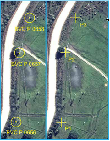
An example of its importance and application can be seen in the figure. In this case, a case of georeferencing of the rural property (Law 10.267 / 01) is shown, the differences of the coordinates of vertices type "P" obtained by the fast static method (GPS L1 / L2) and directly measures on a high resolution image, right. The 2 WolrdView2010 satellite image was georeferenced with a result of a positional resolution of 1,5 meters, that is, any of its figures can not differ by more than one and a half meters from the actual position, which is the limit currently accepted by Incra in the reoccupation of points. As noted, all differences are less than the specific precision. The 1,5 and 2,5 positional resolution adaptations, respectively, enable the dissemination of the secure application of the remote sensor to reduce costs and deadlines in determining coordinates of unverified vertices and natural boundaries, visible from above. The professional georeferencing of different images, with the same positional resolution, results statistically in readings of coordinates within the same limits and, therefore, a second professional can easily verify the coordinates of the first. The owner, who pays a lower price, wins the professional, who has a lower cost with the same profit; and wins the country, which reduces the term and development and certification of millions of properties.
Georeferencing of rural properties: "P" vertices along the entrance, measured with GPS L1 / L2 (direct) and directly on a WorldView 2 (direct) image. The image has geometric resolution of 0,5 meters (observe oxen on direct) and was georeferenced to reach positional resolution of 1,5 meters.Absolute differences (meters)
BVC P 0658 - P3 = 0,91
BVP P 0657 - P2 = 0,43
BVC P 0656 - P1 = 0,55
As for the secular scale, it is inevitable that she ceases to be the protagonist of the qualitative specifications of digital cartographic products and becomes an eventual co-helper. It is like Google Earth, where it is available below, is direct, if you "Ascend", what is its importance ?, we want to know, in fact, every time we extract a form, measure a segment or get a coordinate, and what is the positional resolution of your images, to know what we can do with the information extracted. In the meantime, your concept and your reference will certainly remain in the corners of our mind and documents. An honorable tribute to a fundamental resource for 500 years, that among so many merits brought to our ancestors and helped us to build a better world that we now enjoy.


Very interesting article analyzing the usefulness of scale in this digital world of infinite precision. Frankly, I see it quite right, I could sucribir it but, in my opinion, I do not think that the scale should be left aside when producing any graphical, cartographic or planimetric information because, although the product and even its byproducts are digital, Always, before or after, in one form or another, physically or again in digital, development will be subjected to an impression, and it is then necessary to apply these concepts error, appreciation, accuracy, etc.
Ah! A pleasure to enjoy geofumadas, which I prematurely commenting and, well, it is not another to recognize it, right?