
Today I had a meeting with a foundation of great importance in the Central American region, and it has made me very happy to know that they have joined the commitment to promote gvSIG for municipal use.
I am referring to a Municipal Development-oriented Foundation, an institution that has existed since 1993 and has been developing projects in the Central American region. I heard about them a few years ago, when they were working with USAID funds promoting the modernization of municipal processes, which included the financial area, cadastre and some land use planning… although they do much more than that.
In the 3s, this foundation developed a tool known as the Municipal Integrated Information System (SIIM) that included modules for use by the Budget, Treasury, Tax Control, Accounting and Cadastre departments as a priority, although it also included others. Back in those years, a monolayer build on Visual Fox and rudimentary links to ArcView XNUMXx via raw shape files.
Now I have seen the version to which they have migrated, according to its executive director "A complete redesign”In what is called the SIGMA Advanced Municipal Information and Management System. The system presents a multilayer infrastructure, the user layer is totally web, developed on .NET C # and with a MySQL database that serves data via asp from a server with Windows Server 2003. I have seen the functionality and it seems quite interesting We'll talk about it later.
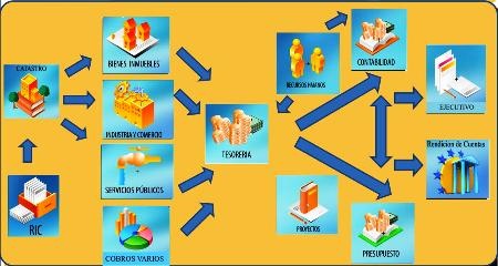
To date, the system has at least 13 modules, aimed at managing most of the municipal activity on finances and the tax application registry. These are the modules:
| Element |
Module |
|
|
|
|
|
|
|
|
|
|
|
|
|
|
|
|
|
|
|
|
|
|
|
|
|
 SIGMA is a redesigned version of what the previous SIIM was, with greater conceptual clarity. This year we will coincide in seven municipalities where one of my attempts will be to connect Manifold to this platform, but I also believe that I will seek to implement the cartography of a municipality that is starting from scratch on gvSIG, aware that these people will be able to take advantage of the experience to continue it in others territories.
So far the system is functional at tabular level, but when I ask them as they have walked with the geometric management I have left a good satisfaction:
They will work with gvSIG.
For now one of the boys of the foundation is taking a master's degree with the University of Girona, I hope to associate them with The other institution I mentioned before in order to promote the dissemination of this tool for municipal use, and in the long run who knows if with them we will promote free GIS sessions in the Central American region. I'm not sure if you dare to join the III GIS Conferences Free that are next, I still have a meeting next with them.
To the extent that these institutions get involved in the use of free or low-cost applications, we will have better practices and greater sustainability of the projects. From what I know about this foundation, which by the way is non-profit, we will have to talk about in the next 10 years because its experience for more than 15 years in the simplification of processes and modernization of procedures is extensive; so we'll see if they walk on the subject.


Great job, congratulations. We are working with some municipalities in El Salvador interested in implementing GIS. Please get in touch.
I am a student of environmental management in Venezuela and I am directing the use of this software in a project for my municipality, in that sense I would like to see more information about this excellent initiative to have it as a reference in my study would be very useful for me and Thanks in advance!!!!