
How to make IMS with Manifold GIS
1. Enable IIS Internet Information Servers
IIS, for those who were born after 90, is what used to come in the Windows NT Option Pack, Windows XP Professional already brings it integrated, although it usually has to be activated.
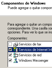 To do this, it is done: "start / control panel / add or remove programs / add or remove windows components" and there it is activated, then following is applied and the operation is finished.
This allows to use the equipment as a local or remote server, and although it is used for PHP or PERL, Manifold is made to publish in ASP, which is integrated in Windows.
When I asked the question of whether it could be published in an Apache I was seen as gentle.
2. Understanding the structure of Manifold.
Manifold manages a structure known as Project, which can have this type of components, I mention them from top to bottom:
The data sources can be inside (as in the geodatabase) or they can be linked externally, such as tables or images. So the .map file contains everything inside and they can be:
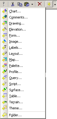 Data Sources
 - Boards
- Drawing (vector data)
- Images (raster data)
- Data organization
- Folders
- 3D analysis
- Lifts
- Profiles
- Surfaces
- Models of terrain
- Result
- labels
- Graphics
- layouts
- Maps
- Others
- Comments
- Forms
- Palettes
- Queries
- Scripts
- Themes
The previous organization is my invention, it is not in the manual but it is a way of organizing the different types of components.

3. Preparing the map to publish
In my case, this is the project that I have organized:
If they are fixed, I have created folders based on the categories, within which are the different components.
In the case of the cadastral layer, within it are included the labels (labels) and in the case of the images, within it they can be until the Google images are either linked or imported.
The properties of zoom min / max, projection, datum and precision are carried by each component.
At the bottom I have left the maps, which are displays of data that may contain different layers, even with different projection but reprojected on the flight over the projection assigned to the map.
The life of the publication is in preparing the map, the layers, transparencies, labels ... all that will be recognized by the IMS service.
In this case, I created the cadastral map with these characteristics:

I hope they tolerate that I have placed such a large image, but it is a way of explaining it, if you look at it, the cadastral "map" has all those layers activated, and in the display you can see them. In the case of the properties I have themed them by quadrant map and in the background I have left the Google Earth image.
4. Creating the IMS map
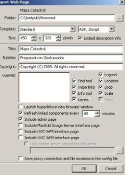 The above was the most complicated, now you just have to do "file / export / webpage"
Here you configure the export folder, the template, if you want with frames or ASP.NET, window size ...
It is also defined if you want to see legends, scale bar, layers or search bar.
Finally, you can define below if you want the interface for external images and the interface for WMS / WFS services to be included so that others can connect to this service.
There is also a space to define each when you want to refresh the changes that arise in the original map to the maps served.
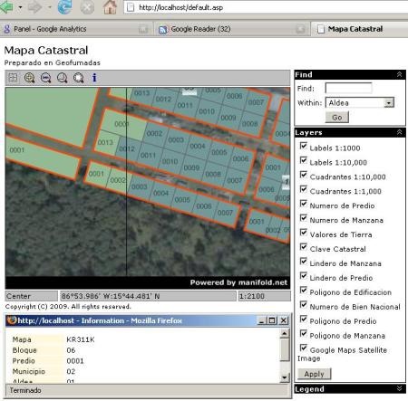
And that's all gentlemen, this is the result.
Sure, if you get to work with ASP and the GUI, you can make a better template and create more controls than the default ones. Here I leave link of a site worked a little more on Ajax and with the personalized interface.
Cost?
A personal Manifold license is worth $ 245
In order to do IMS, a professional license, add $ 45 or $ 295
Although if you want to put it on a server, you only need to put a professional runtime license that costs $ 100
The cost of learning ... as I recall, a geofumado friend explained it to me in 14 minutes ... and it took me 23 to do it only when I arrived at my house after suffering because the Windows Home Edition does not bring IIS !!!
Ah… they can also do it with ArcIMS, GeoWeb Publisher or with MapGuide, although it will cost them a little more.


