Sample GeoSpatial Training Worksheet
GeoSpatial Training is promoting its new edition of courses, so we take advantage to spread some of what their students have done and the list of new courses.
Advances of recent students
From the Javascript master for ArcGis Server, Javier Pampliega has created the application below from scratch. A good job in which much of what has been learned is reflected. http://goo.gl/PgBdT

Awards of the first edition
For those who have followed the trail to this offer, they will know that in The previous edition of the courses An award was made to the most innovative works, and of these here we show the winners:
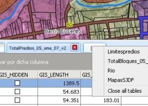
- La primera Application is a development of Mario Santos Cruz Worked with the ArcGIS Server JavaScript API. A simple viewer with basic visualization tools and a geoprocessing task to search for entities at user-defined points.
Www.stian.com.mx/demos/demoGeospatial
User: demo
Password: ABC123 $ 2012 $
- La second Have built it Oscar Javier Castillo y Efrain Andre Laverde With him ArcGIS Server JavaScript API For iPad. Superb finishes and robust operation. Here some screenshots although it is a pity that they have not promoted a domain where it can be seen. Either way we leave the mails in case someone is interested.

List of layers
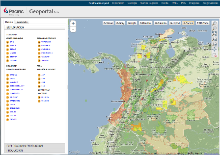
Home Screen
Offer online courses.
Finally, to inform that in October new sessions of the online courses begin and for this session the possibility of taking the course of Introduction to Web Development for Free If any of the courses is done:
This is the list of 9 courses to start
- Open Source Web Development + Introduction to Web Development : October 1 - 1 November 2012
- Developing applications in ArcMap with Python: October 1 - 1 November 2012
- Master in development with the ArcGis Server Javascript API + Introduction to Web Development : October 1 - 1 November 2012
- ArcGis Desktop 10: October 1 - 1 November 2012
- Introduction to the GoogleMaps API (3 version): October 1 - 1 November 2012
- Developing applications with the Flex API for ArcGis Server: October 1 - 1 November 2012
- Basic gvSIG: October 1 - 1 November 2012
- Spatial Analysis with ArcGis Spatial Analyst 10.0 (Introduction to ArcPy and GDAL): 1 October - 1 November 2012
- Introduction to Web Development: 11 of June - 11 of July of 2012