Geobide, interaction with OGC data
Something very important for current CAD / GIS applications is the ability to interact with data served in standard formats by state or deconcentrated institutions.
In this regard, the role played by the Open GIS Consortium and Open Source initiatives has been valuable, such that now the term interoperability is associated with the standard data service and not the reading, importing or transformation of files. Hence, the terms IDE and geoportals are now better known.
Geobide is one of the initiatives that has recently caught my attention, since despite being proprietary, it does not intend to become another CAD / GIS tool, but rather works with data from existing platforms. Both with Microstation data, such as AutoCAD or ArcMap, it does it very well.
Let's see what happens with OGC formats.
This is an example of Navarra's spatial data infrastructure (IDE), where geospatial data exist both in the Electronic Headquarters of the Cadastre, in the case of the State; he Territorial Wealth Service or the IDENA portal (Spatial Data Infrastructure of Navarra).

in the case of IDENA, when selecting the link showing the OGC layers, the following display appears:

If we want to do this with GeoMap:

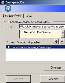
In the top menu, we chose "open raster layerThen, in the host field we write:
http://idena.navarra.es/ogc/wms.aspx
add it and then press the "Connect" button.
A new window will appear, and in this we choose the layer of our interest. Only if we are interested in a different reference system than the EPSG: 04230 ED50, we place it below.
 |
|
When selecting "OK", you should load the layer in the viewer.

This and I am doing it with the previous version, which will soon be just a legacy. The following example is from the new version, showing the cadastral information about the PNOA orthophoto.
It makes it more efficient to display and redraw data when panning or resizing the view. Also the advantage of tabs makes it easy to sync without having to load many layers in the same view.

Good GeoMap capability, not only with WMS layers but also WFS.


