
Generate contour lines with ArcGIS
Carrying out a cadastral survey with a total station, apart from having millimeter precision, can also be useful for other purposes, since we have the elevation of each point. Let's see in this case, how to generate contour lines, which we already saw with AutoDesk Civil 3D, with Bentley Geopak y Manifold GIS, so for educational purposes, in this case we will do it with ArcGIS.
1. CAD data
For this exercise, I have the survey files in dgn, one for each work day. Importing it is as simple as:
- Arctoolbox
- Data interoperability
- Quick import
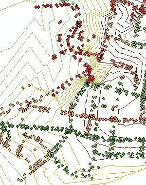
The dgn files are selected, and voila, in all of them. See how beautiful they look themed, you can see the days the boys worked, when they made an effort and when They cheered.

More than interesting, you can see where they took points, in this case almost only in the direction changes of the blocks, to take the fronts and bottoms with a measuring tape. Practical to support the survey method for the time of mismatch with documentary measurements or other surveys. You can also see where they mounted the equipment to look back.

2. Enter points to the geodatabase
 For better handling, I will input the points to a geodatabase. To do this, we assume that it is already created with the ArcCatalog and defined a Feature class.
- ArcToolbox
- Conversion tools
- To geodatabase
- Feature class to geodatabase
3. Create digital model
 Several of these steps can be overlooked, but for the purposes of understanding the use of 3D Analyst, we will see them in this order.
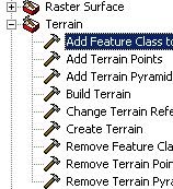
- ArcToolbox
- 3D Analyst tools
- Terrain
- Create terrain
With this we have only defined the name of the model, we will enter the points:
- Add feature class to terrain
- Build terrain
 Now we are going to generate the TIN
- ArcTool box
- 3D Analyst tools
- TIN creation
- Create TIN
You can see that at the ends that there are not enough points the triangulation stays poor, but where the streets are, consistency remains.
I could also notice that due to their innocence, in this lift the boys erred by not conserving the lift in a change of the apparatus. Savable error, by interpolation of nearby points but the observation can be had in time to make the corrective. Also suggest that in the first two georeference points they use the elevation coordinate provided by the GPS and sufficient distance to reduce the rotation error due to the inaccuracy of the GPS.
4. Generate contour lines
 Always within 3D Analyst
- TIN Surface
- TIN Contour
Here we choose the newly created TIN, the target layer and interval between the contours (among others pirouettes Which saves me for space reasons).
The steps are more when compared to Manifold GIS, but the options are much more powerful.
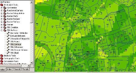
5. Generate slope map.
- TIN surface
- TIN Slope
What is coming is to use this, which can be applied to the design of sewage systems, as this is not only a land survey, but a topographic survey with which you can work street profiles with just a couple of steps .


I find it excellent, but I can indicate with which version you can do the contour lines.
I think these links can serve you:
http://gemini.udistrital.edu.co/comunidad/profesores/rfranco/tutorial_arcgis.htm
http://forums.arcgis.com/threads/14846-TUTORIAL-ARCGIS-10-EN-ESPA%C3%91OL
The first is pay, but I think in this the best way to learn is to invest in a good course.
What good information, just a detail I recently acquired arcgis 10 and I still have problems with many things, could you tell me how to literally start from scratch any tirorial they recommend.
Before working with 3.2 arcview and really feel the difference. I hope you can help me
Thank you very much for the information, from the TIN you can do so much, and here you explain very well how to perform the contours.
Check the internal memory, and look at the configuration, if it is addressing the internal memory.
Also look at the capture time period, if it is too short or if some routine is configured that causes you to do some real-time post-processing.
thank you very much help me, I have a gps magellan mobile mapper 6 v2.1 but I do not understand why I get a data that I need enough memory for the postprocess and practically the external memory is empty that should be
Gentlemen could do a tutor with more details please.
The polylines join them with the command Pedit, in option join multiple. What happens is that they must be polylines, if you have smartlines you can not.
Hi I have problems to join several blocks of contours, someone can help me, clarify I need to join the polylines with the other polylines that is only one is understood? Thank you
Very good explanation !!!
This is great to know that there are always people who have the knowledge and do not hesitate to support others. This excellent creation of contour lines with ArcGis.
You can help me by indicating what are the steps to develop a map of slopes and logging of a forest. My email is Jalfremar_59@yahoo.es And my name Jose Alfredo Martínez, Honduras.
Thank you for the logistical contribution, your information has served me in good time
UFF¡¡¡¡¡¡¡¡¡¡ EVERY DAY THEY SURPRISE ME MORE WITH THE HELP PUBLISHED ON THE WEB, ESPECIALLY GEOFUMADAS 2.0, THANK YOU FOR THE CONTRIBUTION MAN ...
This is very well this explanation I would be very grateful to teach me from the beginning how to generate contour lines