
Export list of geographic coordinates to Google Earth, from Excel, with image and rich text
This is an example of how Excel can send content to Google Earth. The case is this:
We have a list of coordinates in decimal geographic format (lat / lon). We want to send to Google Earth, and we want it to show the code of the point of interest, a text in bold, a descriptive text, a photograph of the point and a hyperlink to open a page on the Internet.
Here's the example of what we hope to show by clicking on the dot:
The code is: XL-3458
The length:
-103.377499
Latitude:
20.654443
And this is what we hope to see:
|
XL-3458 Central plaza Mr. Joaquín Gómez Father's house, where the National University initially existed and is now restored as a museum protected by the National Institute of Anthropology
|
Although the template will be uploaded, the spirit of the article is to explain how to do it on your own.
What we occupy is to create the html tags in separate columns to be able to concatenate: The code for this would be:
Central plaza
Mr. Joaquín Gómez Father's house, where the National University initially existed and is now restored as a museum protected by the National Institute of Anthropology
<img src=”http://upload.wikimedia.org/wikipedia/commons/thumb/3/3c/Casas_actiopan.jpg/800px-Casas_actiopan.jpg”width=”144”height=”168“>
<a href=”http://commons.wikimedia.org/wiki/File:Casas_actiopan.jpg“>View website
All labels that are to indicate that it is a separate line, closing with a which is equivalent to an Enter.
Then, the is a label to indicate that this text is in bold, of course closing it with a
Im is a tag for the image, which carries properties such as the width (width), height (height) and the address where the image is (src)
Finally there is the label for the hyperlink, which opens with
The marked in purple is content that would change with each image, so we will be interested then to leave it in cells.
Without much turn, you can see then that the concatenate function would be summed up to something like this:
= CONCATENATE(,CELL,,CELL,,CELL,<img src=”,CELL,”width=”,CELL,”height=”,CELL,“><a href=”,CELL,“>,CELL,)
Which implies, that we will occupy 8 columns to store all the data that we want to show. Although in the case of those that have labels that use the = symbol and double quotes, it is complicated for us because in Excel the first indicates a function and the second is used to separate textual content. This is solved by placing those contents in separate cells as if they were text.
Finally we have this:

And to send to Google Earth I have placed a button that generates the file.  There you specify the path where the file is and the name we expect to have the description of the kml when it is displayed in the left panel.
The template has some mouse over cell prompts to suggest how the data should be entered. In general it tends to have a problem when macros are not enabled and when the path where the file is being created is not writable.
There we have it, you can do search by code in the sidebar of Google Earth, and clicking on the point is shown as we expected.

 Download example kml
It requires a symbolic contribution for the download, which you can do with Paypal or credit card.
It is symbolic if one considers the utility it provides and the ease with which it can be acquired.
Learn how to make this and other templates in the Excel-CAD-GIS cheat course.

Common problems
It may happen that, when using the application, one of the following incidents may appear:
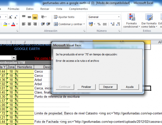 Error 75 - File path.

This happens because the path that has been defined where the kml file is to be saved is not accessible or there are no permissions for this action.
Ideally, you should put a path on disk D, which has fewer restrictions than disk C usually has. Example:
D: \
The points are coming out at the North Pole.
This usually happens, because in our windows, as indicated in the instruction for the template to work, the regional configuration must be established in the regional panel:
- -Point, for decimals separator
- -Coma, for thousands separator
- -Coma, for listings separator
So, a data such as: One thousand seven hundred and eighty meters with twelve centimeters should be seen as 1,780.12
The image shows how this configuration is done.

This is another image that shows the configuration in the control panel.

Once the change is made, the file is generated again and then, the points will appear where it corresponds in Google Earth.
If you have a question, write to the support email editor@geofumadas.com. It always indicates the version of windows you are using.


I have already downloaded the template, I will study it and I will write any questions or modifications. Thanks g '
Hello Jose Luis
We have already corrected the link.
regards
No link appears for payment via bank transfer. I am from El Salvador. Thank you.
I would like to buy a template but I do not have a card like I do
Check, you're sure to be putting the downturn back. This is an example:
D: obrasalc
Download the Excel file, and I have difficulties uploading photos from my disk D: /works / alc, please can you send me an explanation how I can upload the photos from that address.
Do the photos have a specific size? Or you can work with photos of 4 mb
Yes, of course you can locate local routes on a computer or network
It is possible to read images stored locally on PC or using network drives. Thank you
Can this application read images stored locally without using a URL?
Hi, I'm interested in contruing your plantillas.soy de peru, but when I give you the bank account transfer link, I do not get anything like this to deposit the money
We regret the incident, but we have already resolved and the payment system is already enabled.
Greetings.
I would like to pay for many of the plans that are here and I can not
Yes.
The macro has no protection key so it can be modified.
The download includes the power to modify the source file or the main macro of the program in excel.
It is not datum failure, it is that the Google image is displaced
Indeed, the datum I have in Google Earth is the WGS84.
Have you found the reason for the failure with my data?
Send them to the post office to see them. Send me the table in Excel and the kml file that it generates. Editor@geofumadas.com
Check if you are using the respective Datum, Google Earth uses UTM WGS84.
Thank you for the speed in the solution that has worked. However, when I run the "kml" file with Google Earth, almost none of the coordinate points appear and only a few are seen, almost always the 1st and last of the series, but quite far from what corresponds (100 Kms. pe ). I'm bored of doing tests and nothing. Can I send you the file with the loaded data to some e-mail? So you would see what happens. Thanks,
That is a known problem, as it is written above.
Change the path, you are putting the file to be created directly in C: and that is often not allowed by the Windows configuration. Use another route and make sure it exists.
The program seems great and I had a hard time finding it.
I have achieved against payment of 2 $ but it turns out that when I run it does not work and a notice says:
“Runtime error '75' occurred.
Path or file access error”
I appreciate if you can tell me how to solve it or if you send me another Excel file, as soon as possible, because I have to prepare a work of representation of geographical points and I am quite late.
Regards,
It depends on the displacement.
If they are displaced a few meters (10 to 15 meters) is because the image of google is displaced, you can see it by changing the image to previous years and you will see that the georeference is quite bad. Although the coordinate is correct.
If the displacement is greater, it could be that they are coordinates of another Datum. Google uses WGS84.
If the coordinates fall in another area of the planet, it could be that you are entering upside down latitude and longitude. Or you are not using the sign: In the western hemisphere the length is negative, in the southern hemisphere latitude is negative.
Very good contribution only that you notice that when I put my coordinates it does not show me exactly where it is ... why do you think it will be?