
The Trans 450, Rapid Transit Bus for Tegucigalpa
This is an interesting project that now takes place in Honduras, under the modality of Bus Rapid Transit (BTR). Although it is now in that stage of understanding before the carriers that do not have the clarity of how cities evolve, it seems to us one of the milestones in the development of the thematic axis of Territorial Organization and Urban Mobility of Tegucigalpa.
The concept is recent in countries of the Central American area although it began in the 70 years in Brazil, from where it has reached many countries of America like Colombia, Ecuador, Argentina, Peru, Chile, Mexico, Canada, the United States and in different countries of Europe And Africa. It is popularized in countries with overcrowded cities such as China and India.
And it is that in itself is not simply more buses glued by the tail, but a methodology that includes the gradual construction of trunk systems that operate without affecting the rest of traffic, with feeder, exclusive lane, security system, scheduled routes, geolocation and With at least two main intentions: Be a fast transport system and maintain a quality service. Both challenges are the main problems of traditional transport systems and where there will be much to work beyond the technical aspect in one of the cities with recent bad pejorative in terms of security and ordering.
The Trans 450 has a page with information that should be of interest to all of us who are associated with Territorial Planning, analyzing its evolution and impact is more than useful. We promote it because the good things that happen should motivate us to counteract That pessimistic spirit To believe that we have no solution.
So here are the two important aspects of the Trans 450 page.
The planning and structuring studies of the first phase.
This includes two documents, the diagnosis and a presentation with the analysis of current 12 routes, showing the behavior on a working day and a festive one in regards to the SUBE / LOW.
- With this the pattern of mobility of the users in the area of influence is known.
- It also determines the load profiles through the volume of passengers per stop of the routes surveyed

The top map shows the disaster how those 12 routes now operate. The chaos of a bus stopped for half an hour at a station, stops in places not indicated, the blocking of two lanes to hinder the other one that is coming ... all because the same passenger is fighting.
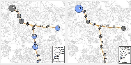
These maps show the demand of users by stop station, to the right one working day, in gray the SUBE and in blue the LOW. See how on the weekday all the low concentrates on the final point while on the non-working day the stop stations are the malls of the road.
The BTR systems operate in function of travel and not of captured passenger, with which the user can be guaranteed time and periodicity. There is a lot to learn from both documents, although the presentation is only the summary of the complete study, it shows between the lines how the conceptual model works, how the tariffs are worked and the institutional articulation so that it is public but maintains its quality.
View studies
System Mapping
This is mounted on the Google Earth API and shows structured interest information in the following layers:
- Administrative. Here is the urban boundary, the municipal boundary and the neighborhoods / colonies
- Trans 450 routes. With linear geometries of the trunks and feeders
- Stop stations
- Construction phases
- Characterization. This seems to us an interesting category, where the colonies are thematized by the degree of social vulnerability and demand.
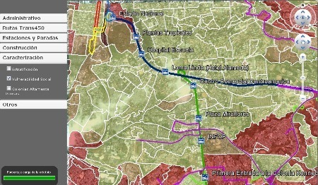
Although they are kml layers with an AJAX interface, we think it is a valuable initiative to show the population with Internet access which is not easy to explain in a short TV report and will surely have more information as the development of the Internet progresses. work.

Here is the model mounted on TransCAD, Caliper's CAD / GIS software
View Map Page
In general, it seems to us an interesting initiative that is no longer new for other countries and beyond the specific approach that we have given to the good image of the website, for Honduras it constitutes an important step in the modernity of its capital. Almost with similar inspiration to the design of its main boulevards and peripheral ring in the seventies ...
http://www.trans450.org/


