
Download utm zones for Google Earth
This file contains the UTM zones in kmz format. Once downloaded you must unzip it.
Just as a reference ... the geographic coordinates come from dividing the globe into segments as we would an apple, vertical cuts made by meridians (called longitudes) and horizontal cuts made by parallels (called latitudes).
To enumerate the latitudes is part of the equator, north or south from zero to 90 degrees at the poles and these two halves are called hemispheres.
In the case of longitudes, these begin to be listed from the Greenwich meridian called the zero meridian to the east, they are listed until reaching 180 degrees, where this same meridian divides the earth (called antemeridian), this half is called " East". Then the other half is called West, generally represented by the W (west), the meridians still start from Greenwich but in the opposite direction from zero to 180 degrees.

Thus a coordinate in Spain can be Latitude 39 N and length 3 W, a coordinate in Peru would be Latitude 10 S and length 74 W.
This way of determining the coordinates that does not have to do with an altitude above sea level, since it is a vector that starts from the center of the earth towards the surface, this is the projection that Google Earth uses, and this is the way of coordinates used by kml files, additionally a reference spheroid is added which is the way to approximate the surface of the earth for measurement purposes. Google uses WGS84 as the reference spheroid (although there are tools that allow you to enter UTM coordinates into Google Earth). The greatest advantage of this projection is that the coordinate is unique on the surface of the earth, although the handling of operations to calculate distances or bearings is not practical for "non-geographers".
The UTM coordinates
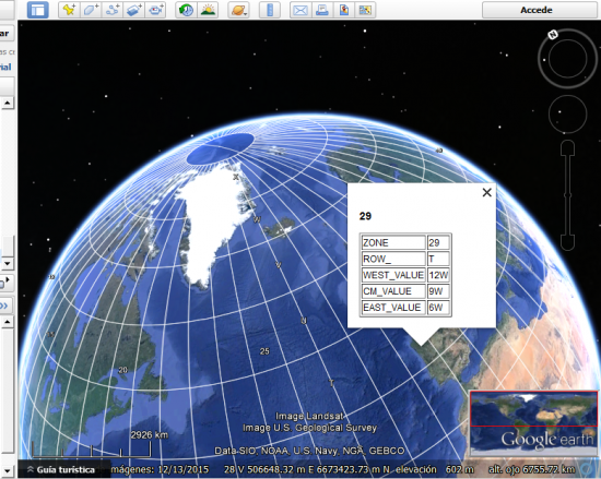
The UTM coordinates are based on the idea of considering a reference spheroid from the cylindrical Traverso de Mercator projection. The earth is always divided by meridians, in segments of six degrees forming a total of 60, these are called zones. The numbering of these areas is starting from the antemeridian, from zero to 60 from west to east.
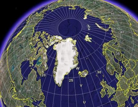
The segments that generate the parallels go from 84 S to 80 N, and are numbered with letters that go from C to X (“I” and “O” are excluded), each segment has 8 degrees of latitude except the X which has 12 degrees.
The A, B, Y, Z are used especially for the polar ends; Google does not include this segment because it requires an infinitesimal calculation in an area of interest only for polar bears :).
 In total 60 zones are 6 degrees each, as well
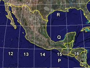
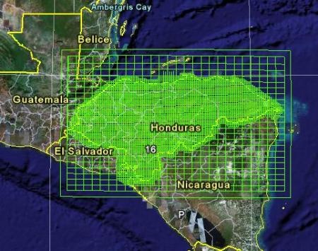
- Mexico falls between 11 and 16 zones
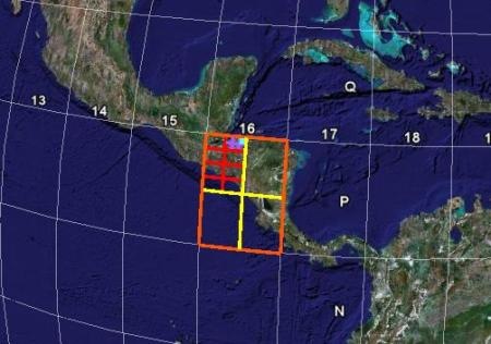
- Honduras in the 16 and part in the 17
- Peru between 17 and 19
- Spain between 29 and 31.
The approximation of the reference spheroid to sea level makes the arc formed by these lines have measurements that are quite similar to the reality of a local measurement. This reference spheroid, previously (popularized in Latin America) was the NAD27, currently the NAD83 is widely used, known by many as WGS84. By having different horizontal reference, the grids of both spheroids are different.
 So a zone has a starting x, y coordinate, in the case of Central America, the limit between zones 15 and 16 has an approximate coordinate of 178,000 and goes up to more or less 820,000. This coordinate range is the same for each area, at the same latitude but we clarify, it is not an orthogonal grid but for local measurement purposes, it is quite similar. The boundaries between zones are closing, but everything starts from a central axis, where there is a totally vertical meridian whose length is 300,000 known as "false east", so that both to the left and to the right of this meridian there are no units negative.
The latitude (Y coordinate) starts from 0.00 at the equator and climbs to the north pole with coordinates near 9,300,000.
The maps that we know for cadastral purposes, with scales 1: 10,000 or 1: 1,000 arise from the partition of this zone, in a post next explain how this partition comes.
A geographical coordinate, such as 16N 35W is unique, however a UTM coordinate such as X = 664,235 Y = 1,234,432 equals a point that is repeated in 60 zones at that same latitude, both in the northern hemisphere and in the south; Requires an area and hemisphere to define where it belongs.


I want utm map.
It's not possible. An utm coordinate can be repeated at least twice in x and y of the 60 zones utm
Is there any way to calculate the spindle having UTM coordinates?
My dear, I live in Nicaragua. We eat Salvadoran pupusas in Altamira and I'll explain.
Greetings.
Editor@geofumadas.com
I've been reading topics on your blog for about 4 years. The fact is that I downloaded the UTM zones in GEarth. I have the grid of topographic maps of Nicaragua (those sheets that "measure" 10' latitude x 15' longitude. The idea is to bring them to GEarth in a similar way to the UTM zones. I am not skilled with AutoCAD but I am somewhat skilled with Excel. I tried to solve it like this: In Excel I have the coordinates of the corners of each sheet (obviously they are not repeated in the neighboring sheets), I made a .txt and with Geotrans I converted them into UTM WGS84 with the idea of taking them to AutoCAD, moving on to DXF then to .kml but my problem is my ability with AutoCAD maybe I'm taking a big lap, the thing is I could never draw lines or polygons in GEarth I would appreciate if you point me to a blog post that can help me. Thank you very much from Managua.
Very interesting, later I will need some tutorials, thanks for the information, byee
you're wrong wey that application is already on the google earth
I have already corrected the link. It was wrong.
Nothing is downloaded. The link leads to another article. Geofumadas ????