
Connect Virtual Earth with ArcGIS 9.3
If Microsoft wants to get serious about the geospatial world and gain ground from Google, it must partner with specialized software companies and make it "more professional." This is what happened in the case of him launch of TrueSpace to ridicule Sketchup !, now with the agreement with ESRI, it seeks to reach the users of the dominant company in the geospatial market.
From ArcMap and Arc Explorer. It is possible to connect to the Virtual Earth images that will now be in the online service catalog. It is possible to do both the image and Street Maps and the hybrid service. Until now the only one who did this ... and for free it was manifold.

Of course it is only possible to do it with the 9.3 version and only in ArcGIS Desktop and ArcExplorer, although apparently something can be done to publish but you have to To contact With Livemaps mara; If they remember Arc2Earth Does his pirouettes about it.
From the API
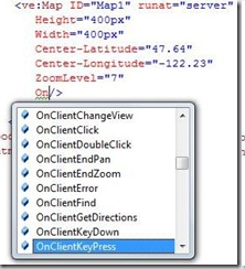 It has also been created a control For ASP.NET that allows you to incorporate Virtual Earth services through applications developed with Visual Studio 2008 and Visual Web Developer 2008.
This is different from the ESRI extension to integrate VirtualEarth to a web application using Javascript.
Nothing is free
Of course, it is not free, the cost is $ 200 per year per user that can be justified in an institution that takes advantage of it. This price is only to "see" with desktop tools, to use it in IMS services it must be another price. And although many may criticize that in Virtual Earth there is not much high-resolution image of "non-American" cities, the last update Shows that Microsoft is very serious.
The next step is surely to do the same with AutoDesk, which many would be happy with and Google would be in an urgent need to break free to open source applications.
If I were Microsoft, I would give it for free for a few months, so really addicted, maybe a step like this is being reserved for the conference that is coming ... well we miss an ad like this before the event.


Hi, I love your blog and hope we can share links.
http://www.ficunfv.com As soon as you link me send me a message that I will immediately link you in my directory and thus we will benefit both of you take care we will be in contact