
Point Clouds and Synchronization with Google Maps - 5 What's New in Microstation V8i
The possibility of interacting with Google Maps and Google Earth and handling of data from scanners are some of the urgent expectations of any GIS - CAD system. In these aspects, no one doubts that free software has advanced faster than proprietary software.
Right now I'm reviewing the second Microstation V3i Select Series 8 update (8.11.09.107), and it's good to know that there is progress. Let's see some novelties that have come in both Series 3 and Series 2:
1. Synchronization with Google Maps
In an earlier article I mentioned Sync with Google Earth. In this case, they have added one more functionality that allows the current view of the dgn / dwg file to be synchronized with Google Maps, being able to additionally choose the zoom level.
This is done since Tools> Geographic> Open Location in Google Maps
Before clicking on the screen appears a floating window that allows us to choose the approach level, which can range from 1 to 23.
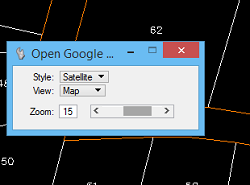
It is also possible to choose the view, which can be: map, street or traffic.
And you can also choose the style: map, hybrid, relief or satellite.
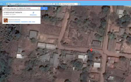
As a result, the system opens in the Internet browser, with the chosen deployment.
Not bad, but it is difficult to understand why it is not as simple as adding it as a new layer ... in what I have known, it is the next thing they will do in the next version.
2. Saved views
It is a functionality like the one that other CAD / GIS programs have had for a long time, which facilitates the possibility of saving a direct access to a specific deployment. With the big difference that Bentley applies the view configuration options, where it is possible to define which layers will be active, what type of visible objects, view perspective, among other things.
It is even possible to define which files are called reference, and visibility condition.

3. Support for Realdwg from AutoCAD 2013
We know that in 2013 AutoDesk modified the file, which will be valid for AutoCAD 2014 and AutoCAD 2015.
Microstation Select Series 3 can open, edit and save these types of files natively.
In this, the agreement with AutoDesk has been a great achievement, which all OpenSource companies have been unable to sustain. Not even to import, much less to edit natively.
4. Point Cloud Support.
This is a feature that started with Select Series 2. Although in the new edition they have added usability improvements.
You can handle points in formats:
TerraScan BIN, Topcon CL3, FLS Lighthouse, LiDAR LAS, Leica PTG - PTS - PTX, Riegl 3DD - RXP - RSP, ASCII xyz - txt, Optech IXF, ASTM e57 and of course, Pointools POD, technology that achieved this after its acquisition in recent years.
5. Support for developments in virtualized environments.
Server virtualization is a recent issue, but has grown in functionality as we now have better controls over trust and broadband connections.
With this, it is possible for different servers to share processes, transferring open sessions and distributing the capacity to other servers without having to be physical like 10 years ago. Thus, services such as what GeoWeb Publisher or Geospatial Server does can be in a cloud of servers, without the fear of saturation or the need to have exclusivity due to the overload that old-fashioned processes implied.
In general, we find the novelties of Microstation V8i interesting in its third series. Although some aspects of geospatial issues always go slower than OpenSource energy, at the level of vertical applications in industrial plant engineering and Civil Engineering it continues to be an important benchmark in sustained innovation.


