
Bentley Hotels
Bentley Sign is a special application built on Bentley Map from the XM V8.9 version and as its name says, that's what it is for; for Cadastre. For its operation it requires Bentley Map, and in itself it is equivalent to a module for controlled cadastral maintenance.
The priority focus of this application is on topology integration, a property that comes out from the moment when the geometries could be inside a database. Hence, a territorial object can understand if another is its neighbor, if they share boundaries, if they overlap and even if it contains an object inside that constitutes a hole.
With this Bentley did not leave the criticized stubbornness from the models of Lemmen that insist on keeping using centroids (nodes) and regions (boundaries), as it also appears in the first coverages of ArcInfo. Although they are very deep and good smokes, Geographics was incapable of handling complex geometries such as one property within another, since it turned them into a cell, making their spatial analysis impossible; they are called complex geometries but they are very common in cadastre, let alone in cartography.
 As of version 8.5 of Microstation, the technology known as XFM is implemented, where an xml structure keeps the tabular data defined in schema stored, and then the map can have the information requiring an attached table. Also the schema can be configured so that it only sees data from the external database and this is only the interface to feed it, edit it or simply visualize it.
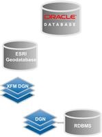
The Bentley Cadastre multilayer architecture is very robust, it is even designed to be able to interact not only with products within a Bentley Map project. It supports development under these connections:
- Oracle Spatial, 2 and even 3 layers
- ArcGIS, three layers
Of course, it has full integration with XFM projects in dgn formats and connects to any RDBMS / DGN supported by Microstation.
Limitations of Microstation Geographics
One of the major disadvantages of the space cartridge was that setting topological standards was complicated. In addition, the entire resource of the servers was eaten because the high CAD precisions complicated the spatial analysis or the simple query of the database.
Due to this difficulty in the topology at the database level, the Topological analysis In Memory. One of the disadvantages was the extremes of rigor that Geographics had (and has?) Since topological cleanliness was necessary to take it to extremes of 0.00001 in Dangles y segment To maintain consistent layering or thematization in the Publisher vpr.
These details were absurd considering that a property does not require measurements less than one millimeter. And what about the integrity between reference files ... that required not only sharing boundaries but also nodes or the geometries were not recognized when creating a topological layer.
Topology Implementation
Bentley Cadastre implements topology in three types of geometries, handling the names Node feature (Point), boundary feature (closed region) and Parcel Feature (polygon). Although the Parcel concept is implemented (similar to AutoCAD Map), it can be seen that Bentley maintains its insistence on the Boundary / node criterion, adding the Boundary / label option, which is now dynamic with respect to the geometry it represents. This insistence can be noticed in the tools that maintain topological control on the fly:
- Parcel feature: Only in the stretch
- Boundary feature: Move, scale, rotate, align edges, paralell, move to contact, modify, extend, trim, insert vertex, delete vertex, fillet, chamfer
- Node feature: Move, scale, rotate, align edges, paralell, move to contact
It is thus possible within the database (only mention Oracle Spatial) to set up topological standards so that at the time of building new grounds or doing maintenance (maintenance) activations are activated to make the respective changes or that the system auto-adjust.
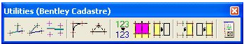
Implements tools for cadastral use
 One of the best advantages of Bentley Register is that it is oriented to what happens in the process of construction, administration and cadastral maintenance from the geometric aspect for which specific buttons have been built.
Actually they are not actions that could not be done with Microstation Geographics, but what has been implemented is the xfm technology and automation that in most cases had to be done by Project Wise and Vba.
Also to the most common data construction and editing commands, xfm capabilities have been added to customize them for the use of cadastre. Finally cogo-compatible tools give you more customization.
Creation of topologies, All of them involve automatic updating of the area, coordinates of the box containing the geometry and its perimeter ... of course, with customization through the Geospatial Administrator you could also update another type of data such as an alert if it requires inspection of the valuation, if you send annotation Marginal to the Property Registry, association to a Project Wise workflow etc.
- Create node
- Create boundary
- Rectangular mapping
- Radial mapping
- Linear adjustment
- Radial fillet to the end
- Project a boundary to a node
- Auto Numbering
- Group plots
- Export parcels to work lines
- Construct topology from nodes
- Construct topology from work lines
- Cogo editor
Maintenance of topologies
- DismemberThis has several very interesting functionalities, including partitioning of irregular plots from a baseline, being able to divide into equal parts. You can also search a specific area with an orientation line.
- Group, With this can be grouped one or several parcels, the process can be configured so that the new property retains the cadastral key of the greater residual area or if a new one is generated. li>
- Modify, This is in the case of moving a boundary, maintaining the topological integrity to the flight.
Implementing it is easier than migrating
In another post we will talk about this in depth, because the implementation is as simple as building it from scratch but migrating a complex project from Geographics at Bentley Map It should not be so simple for reasons like these:
- Objects in Geographics could have multiple features, moving to Bentley Map would require separating those features into separate objects and creating topological rules of integrity.
- The objects of the dgn usually used the historical file to store their mutations there ... and these would go to hell as there is no tool to get them to a tabular basis.
-VBA tools built to automate carpentry: register maps, link building, calculate apc (area, perimeter, coordinates), renumbering, topological analysis ... etc, must be adjusted because everything they did already brings it in buttons.
-The control via Project Wise, was only the right to check out on discrete files, to reduce the size of the files. In this case, all that control must be rebuilt to create access to individual land objects.
-The development of online maintenance application applications that sent the geometry as a redline file ... let's not go any further.
Bentley Prospects Register
 Bentley Cadastre seems to us a great advance of Bentley Map, however due to the fact that they assured that both XM and V8 would be provisional, many of us have been waiting for the promised land of V8i lest the investment in migrating is necessary twice. We also see the disadvantage of staying away from data services that are having a good reception such as Postgre, a tool that many have seen with good eyes after an Oracle license for a large cadastral project can cost $ 30,000 per year just for one server of two processors.
Often times the implementation of Bentley Systems technologies is something that experts recommend for cadastral projects at the country level or large regions, however it would be interesting to measure whether this fondness for the dgn associated with the territory is due to its ingenious technology that allows calling 15 more orthophotos 15,000 properties and after 10 seconds pan on the fly. Or apart from that too Is the provision of geofumar to the sublime with applications that are very powerful but that are not always so digestible by the average user, such is the case of Bentley Geospatial Server, Project Wise and Geoweb Publisher that are necessary to implement Bentley Register.
From 2011 Bentley Sign up Is part of Bentley Map V8i.
Site: Bentley Cadastre


That is: it allows development of applications at the client and server level (Intranet and web).
In this way, it is possible to edit vectorial information about an ActiveX developed for web, be it under redline files or web feature services (WFS) with historical transactional control.
What does this mean for the layers you mention:
“Support development under these connections:
»Oracle Spatial, 2 and even 3 layers
» ArcGIS, three layers”.
Thank you for sharing….
Well written post.
Regards
http://www.sblgis.com/photogrammetry_services.aspx