
Bentley Sign, Schema wizzard
I spoke earlier of the logic and origin of Bentley Cadastre, which is itself an application of Bentley Map Oriented to the land management taking advantages of the xfm infrastructure and topological control.
In my opinion (personal), the implementation of Bentley Cadastre occupies an extraterrestrial smoke in case of starting from scratch, it may be easier for those who already know Bentley Map or at least used Microstation Geographics. As I said before, it has a lot to give (more than what could be expected) but before a common user it brings a first basic question:
How the hell did I implement this?
As requested by users, Bentley implemented what is called the Schema Wizard, which guides step by step the creation of topological characteristics whose customizations will be stored in an xml called schema file. This is what would be done from the Geospatial Administrator, Of which I spoke before and somehow you can consider that this wizard is an improvement in the approach to the user although later with that application can be further customized.
The logic is the same as that of AutoCAD Civil 3D in the routine of creating plots, Of which I spoke when we showed the creation of the heading and distances table but not so simple. Let's see then how the Schema Wizard works
How to activate it
To start it, go to "Start / all programs / Bentley / Bentley Cadastre / Bentley Cadastre Schema Wizard"

Then the welcome panel should appear Which gives us the option to continue, cancel or consult the help.
In the next step it asks which is the seed file with which it will work. Bentley calls “seed file” the characteristics of a file that range from units of measurement, angle format, level formation (layers) to projection and whether the file will be in 2D or 3D. Bentley by default brings some seed files ready in "program files / Bentley / workspace / system / seed".
Now, the seed file you are asking for in this case is an xml, ie a seed file for xfm.
For this there are also some seed files in "C: Documents and Settings All Users Program Data Bentley WorkSpace Projects Examples Geospatial BentleyCadastre defaults seed schemas" and come as examples:
- EuroSchema.xml
- DefaultSchema.xml
- NASchema.xml
In this case I will use the Deafault.
 What to customize
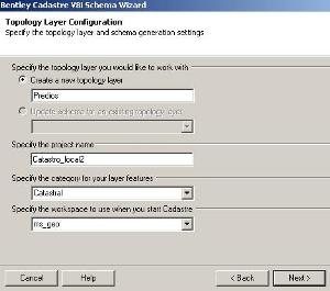
From there, the configuration panel of the topological layer will appear, which will store the plots in which to define:
- Name of the topological layer, by default comes "land", in this case I will call it "building"
- Also ask the name of the project, I'll call it "Catastro_local2"
- Then ask the name of the category, I will call it "Cadastral"
- And finally the workspace name, I'll call it "ms_geo"
 The next panel is to define the characteristics of the closed figure type elements (Polygons):
- Name of the feature class, I'll call it "Poligono_de_predio", it does not accept special characters
- Calculated area name, I will call it "area_calculada"
- Units of measure, I will use square meters and I will call it "m2"
- Then you can add other settings for the parcel labels
Bentley always maintains the smokiness of handling either shapes, such as the anterior panel or "node - boundary" which is the idea of a centroid within a topologically closed area but which can be linear objects without forming a shape. Of course, both layers can not coexist together in the same topology, so the next panel is to configure the linear topology (Lines):
- To the linestrings of the plots I will call them "boundaries"
- At the calculated distance from the boundaries I will call it "length_calculated"
- Then he asks if I want those labels to be shown in linear geometries
The next panel is to establish the topological properties of objects of type node (Points), This can coexist in a same layer with a topology of boundaries and also of shapes.
- Same as above, request the option if you want to label and field name in the xml structure
Finally, it shows a panel of the results of the configuration made so that we can save the schema file. Let us remember that for now we have made a parcel layer, but others could be added with the button "aditional layer" such as parcel layer, urban perimeters, neighborhood, neighborhood, zone, region, sector, map etc.

I will call the schema "Cadastre_local2" and press the "Finish" button; a black screen appears that is storing everything and we are finished.
How to use it
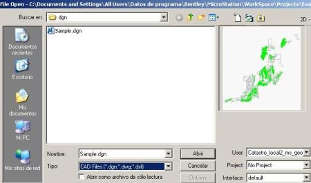
If we observe, a link has now been created to the configured project as seen in the graphic. This is what was previously done on foot with the creation of the "ucf" file and which is stored in the users folder within the workspace, as shown in the second graphic,


Indeed, upon entering, the project already opens in the created folder, it even brings an example file. See that at the moment the user and interface are already defined in case we had defined.
And there you have it, minimal topologies created on the right panel, Bentley Cadastre tools and ready to go. A panel is also displayed to connect to a database the first time.

It is clear that this is simply the basic creation of the schema file to work with a cadastral project, it is obvious that the Geospatial Administrator can do this with a little more pain and customize it to the sublime. We will see it another day.
Co
Inclusion
In short, a significant improvement in the approach to the user of Bentley Map or Microstation Geographics, at least for the creation of a topological xfm structure without starting from scratch with the Geospatial Administrator and the creation of the ucf at one time.
Even so, the user's question continues to be: Well, now you just have to draw lots? because in this the way the manuals are made, oriented to windows and not precisely to processes, falls short.
You can learn everything you do from the user side regarding topology standards and other basic Bentley Map functionalities such as spatial analysis or theming.


Hi Agustin, is it still in use xfm?
Still, although somewhat out of date since in the institution that promoted it, no one understands the issue anymore ... I'm fixing it myself, although somewhat rudimentary ...
Amateur companion, time without knowing about you. Still using the project that was done in xfm?
Hello G! ... I already wanted to know how xfm maps were made ... the tutorial is excellent ...