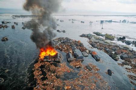
It's just that, awesome. While in Western Europe we were getting up and in America we had the best of sleep, an earthquake of almost 9 Richter shook Japan when there was 3 in the afternoon.
Watching the videos of how the water enters and carries away houses, vehicles and boats is unique. It has been said to be the strongest in 140 years of Japanese history, and fifth in the world. We remember the recent ones in Chile and Haiti, but this scenario is very different.
It is curious to know that the death toll is so low, although it will surely grow as the damaged areas are measured more widely; entire coastal populations may have disappeared. It is striking that in a supermarket, instead of running to take refuge under a column, employees protect the shop windows so that the product of their effort does not fall to the ground. A surprising culture of safety in infrastructures and education on what to do in those cases.
It remains to see what happens in the Pacific of America, which has been alerted, since the effect on the coasts will be seen several hours later. It has already been known that the effect has reached Hawaii, although it does not seem to be as scandalous as journalists and politicians are doing. Although they are moments of mourning for humanity, I had a good laugh when two journalists tried to explain what time they would arrive at the coast of Peru, trying to calculate the number of hours projected, the speed that has been estimated for the waves and the time difference because the wave comes against the time zone.


This map reflects the estimated hours of the effect of the remnant of the tsunami that will reach America. see that in the case of Chile, it is arriving at dawn but already on Saturday. While to Central America between 8 and 12 at night.


