
AutoDesk already has its Google Earth
AutoDesk has decided to enter the 3D visualization, not that it did not have it, but it was very questionable its platform this type of functionalities for its resource consumption in rendering.
When buying 3D Geo AutoDesk puts itself in a good position because this technology (Google Earth style) is very robust not only for visualization purposes but also for the creation of web services. 3D Geo is a very powerful line not only for architecture, but also for geospatial that includes territorial planning, tourism, transportation and other applications.
For the case 3D-city models are several components of geographic data infrastructures (GDI) that range from simple deployment functionalities to development of web services.
LandXplorer 3D Geoserver has solutions not only for serving large amounts of geospatial data efficiently but also client applications. It also includes authoring tools for developing virtual 3D models.
LandXplorer CityGML Studio offers tools and functions for personalization and spatial data management, including digital signature rights.
The Smart Building allows you to create scenarios for effective planning, such as morphological analysis of terrain, distance limits, data communication or information campaigns seeking user participation and apparently data can be mounted to or from Google Earth. Data can even be generated in portable formats by means of a module called Pack- & Go that encapsulates all the information contained within the model and can be viewed through LandXplorer Server or LandXlorer City GML Studio.
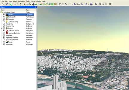
LandXplorer Viewer is a free Google Earth-style viewer, based on web services where 3D-city or 3D-landscape models can be displayed. The difference between the process of how these tools serve the data and the traditional way of existing AutoDesk solutions is that they now work under web-streaming services whereas in the old days they were 3D models through object rendering.
We assume that AutoDesk will integrate the other 3D applications such as Maya, Map3D, MapGuide, Architecture, 3Dx Max and others. Although there were expectations Image Stitcher and Image Modeller that recently announced.


Well, we'll see what AutoDesk does with the toy
Curisa the purchase of 3D Geo and its product LandXplorer. 3D Geo is a spin-off born from the University of Dresden. I met them at the Intergeo held in Leipzig in October of 2007, they left me an evaluation license of the application that I was testing and I did not get any results with my data. The test I was doing was to get a city model directly from a LiDAR data cloud and a shape file with the building enclosures. The app is supposed to do that, but apparently just with your demo data !!!!