INSPIRE progress in Europe
The recent version of Geoinformatics brings a valuable summary of how things are going in Europe in the framework of the INSPIRE initiative, which just last June held the annual conference in Edinburgh. All the reports by country are available by year, but this article constitutes an interesting approximation to the scope of the year 2010, reading it allows to see a global perspective of what can be done in the field of Spatial Data Infrastructures with a regional perspective .
 It becomes valuable a pair of comparative graphs of the article, where Spain takes a pair of recognitions; despite the disparity of its context with other countries less "complicated" in size, legislation and institutional culture.
The INSPIRE directive (INfraestructure for SPattial InfoRmation in Europa) is an astral smoke, which has been going on for several years but which began in implementation from 2007 under directive 2007/2 / EC. Its aspiration is by 2019 to homologate the legislation, regulations and infrastructure of accessibility to spatial data for its optimal use in the development of policies for the European region. Initially addressed to the 27 member states, without preventing an impact that was to be expected, since now there are at least 7 states (Candidates for the EU and EFTA) that are also implementing the process and even participating very actively for a total sum of 34.
This type of approach has been seen in other regions of the world, including the American continent. However, to see what INSPIRE has achieved, considering the complexity of these projects, it shows that there is a lot of hard work done.
The analysis of Geoinformatics includes a review in six aspects:
- Technicians (Data, Metadata and Services) and non-technical (organization, legal issues and financing).
Although each report is based on a unified comparative matrix that includes 9 aspects:

Legal framework and funding
INSPIRE annex data
Metadata
Network Services
Thematic data of the environment
National geoportal
standards
Coordination and organization
Use and efficiency of the NSDI
A graph appears at the beginning of the report, marking in green the aspects that have had the greatest change since the last monitoring with respect to the aspects previously listed.
It should not be a simple task, considering that countries need to take the guidelines to state policies and then follow up on them that are out of the canons until a few years ago accepted in the geospatial issue. For the case, the role of national mapping agencies, such as the cases of Geographic Institutes, have had to gradually adapt to new trends -as already stated in the Catastro 2014 document- regarding public-private linkage. Let's not say the change in the legislation of territories that feel that their autonomy is violated or apparently unnecessary rules are imposed on them.
The case of Spain is mentioned positively because of the effort that is made in linking local governments. France and Italy are also mentioned, although the credit goes to Denmark, well, it has a very particular territorial and cultural context; 90% of its municipalities are highly integrated into the process. And I mention the context because it barely has 98 municipalities, which is like 1% of those in Spain.
Beyond the Geoinformatics article, there is much to learn from the different reports of each country, that despite the fact that the advance format is based on the uniform matrix, each country has lessons to contribute. In this case, the report from Belgium draws attention, which includes precision tolerances for maps at different scales, as well as the different interagency models that in some cases include diagrams, such as the case of Cyprus and Norway.
Another aspect in which Spain excels is in the availability of services. Although the Geoportal is not mandatory, the report shows that at least 18 countries have a prototype IDEE portal. Here Lithuania and France stand out, and emphasis is placed on the case of Spain, where it is said that there is involvement of 7 ministries, 16 regions, 400 municipalities, 833 WMS services, 205 WFS and 9 CSW.

In conclusion, INSPIRE is a clear example of the regional effort for interoperability.  Although it is questionable the limitation of some contexts that do not see quick results, the disparities between countries with cumbersome legislative processes (officials or politicians who do not understand the subject), limitations of physical infrastructure, is to evaluate the systematic work.
Processes like this are invaluable opportunities for the sustainability of the business model in the geospatial field. Both the companies that produce software that consider this region one of their best markets, as the service providers that tend to lag behind, and the OpenSource model that hammers with to gain market space and here you have things to say in terms of collaborative value or defense standards.
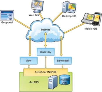
If I am in a municipality with territorial isolation and terrible connectivity, I will surely not find meaning in this inspiration. However, you have to read between the lines, because we are talking about a context where irreversible trends will be marked; understanding this model allows us to agree with geospatial inventive strategies (such as Bentley's hypermodels, ArcGIS for inspire, and CityGML, to give three examples).
Here you can see all INSPIRE reports
Here you can see the report of Geoinformatics


