5 minutes of confidence for GeoCivil
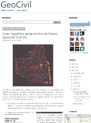
GeoCivil is an interesting blog oriented to the use of CAD / GIS tools in the Civil Engineering area. Its author, a countryman from El Salvador, is a good example of the orientation that traditional classrooms have had towards -almost- online learning communities; No doubt a milestone that thanks to global connectivity is a good starting point for the democratization of knowledge.
In GeoCivil the use of AutoDesk Civil 3D predominates, which is talked about in many articles, both in manuals and tricks to do things. Additionally, complementary AutoDesk programs that do or did similar things like Land Desktop and AutoCAD Map.
 I leave you three links to get stuck, go there and add it to your feed reader.
The article shows how to load a command made in AutoLisp, using a routine that the author did to calculate and label areas not necessarily closed with boundary.
This explains how to download data from an Etrex GPS to AutoCAD, using the MapSource program.
Here he brings us a video of how to split a plot that has an "L" shape respecting a specific area for a plot. Interesting answer based on a question from the Augi community, when he was alive.
And to culminate, here two more articles regarding the handling of topographic data with Civil 3D:
Create a surface from a point file
Survey Link, to download topographic data to AutoCAD
I take advantage of the traffic on a Monday, which by the way is usually very good, to promote this initiative and leave it on the list of blogs that I recommend. If what you want is to learn from someone who has mastered Civil3D, without a doubt GeoCivil is the place.


hello my dear I mostly work with AUTODESK CIVIL 3D and I have data from a place I want to georeference it so the image is very blurry, there will be a command to be able to activate it and have greater signal clarity in GEOLOCATION of civil 3D.
THANKS FOR THE ANSWER
Thank you my dear, I am the one that I maintain geocivil, and it is an honor that you wrote this article on my blog; In fact geofumadas has been a source and inspiration for me, and I consult you often.
Regards,
Hugo