
15 de Octubre, The Blog Action Day
![]()
This year, the Blog Action Day is dedicated to a very sensitive issue worldwide: Poverty.
According to Wikipedia is defined as:
“A situation or way of life that arises as a result of the impossibility of access and/or lack of resources to satisfy basic human physical and mental needs that affect a deterioration in the level and quality of life of people, such as food, housing, education, health care or access to drinking water”
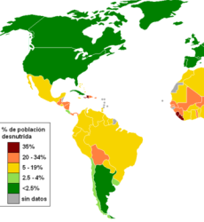
This is the map of the Hispanic environment that shows the percentage levels of malnutrition per country:
Here we can see that in better conditions are Argentina, Cuba and Spain (less than 2.5%),
while Chile, Paraguay and Costa Rica follow (it does not exceed 4%)
All other countries are in a next stage (from 5 to 19%)
and in the queue are Bolivia, Honduras, Guatemala, Panama and the Dominican Republic ... with the exception of Haiti that is above 35%.
The problem with these figures is that they are cold, since those who have access to this blog are not in that queue of poverty, however I want to take this post to remember that the technology, the cadastre and the GIS is composed of people.
I remember the story of one of my colleagues in an endless journey in the rain; so strong that I have appropriated the story as if it were mine:
It was one day, that after two hours of walking on the mountain we arrived with our -not yet obsolete- Trimble ProXR GPS to a home, where they barely had a small bed made from scraps of construction wood and two hammocks made from bags of flour and nylon twine. In the background a child, without clothes, was sitting on the dirt floor, malnourished, dirty, with a look that I will never forget.
They lived in a protected area, with no possibility that they could own their property, they gave us the information regarding the cadastral file and later the father of the family asked me about the possibility of going to live in the city, because they could not stand to live eating bananas.
I went down that mountain, with the indelible memory of that boy ... thinking to myself:
And what do these people gain, with which you tell them that the place where they now grow bananas is georeferenced in UTM coordinates?
I would have liked to do more than give him my replacement shirt, even though it had the institution's logo, he received it as if it had been given to him by Santa Claus. I never returned to the place ... however that changed a large part of the way I see the cadastre as a simple piece of information, as people, as people.
Just to remind you, you probably will not be able to take food to starving children in Africa, but outside the glass where you're eating your hamburger there are other kids who are also hungry.
Happy Blog Action Day… out there there is something to do for poverty.


